
(Heerbrugg, Switzerland) Leica Geosystems, part of Hexagon, today announced the launch of the Leica DD300 CONNECT utility locator and Leica DA300 signal transmitter, a combined, ready-to-use solution for versatile and reliable utility detection.
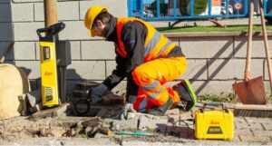
The new Leica DD300 CONNECT and DA300 Transmitter.
The user-friendly solution empowers professionals to make accurate, reliable and in-depth underground investigations and obtain on-the-spot insights regarding the underground network. Novice users can access video tutorials on the LCD display for a step-by-step approach to successful surveys. Meanwhile, expert users have access to a comprehensive range of advanced features. The innovative digital trim, for example, enables manual management of the gain bar to adjust the device’s sensitivity, assisting the operator in pinpointing the desired target in complex situations with multiple underground utilities. Furthermore, the device offers a wider range of acquisition frequencies between 33 kHz and 131 kHz, including a unique 83 kHz frequency which is ideal for long-distance tracing.
The new utility locator seamlessly integrates with the Leica DX Shield software, providing easy-to-use tracking tools and a centralised hub for managing on-site activities and multiple devices. Operators can also connect the hardware to the DX Field Shield app, enabling real-time remote data transfer of cable locator information directly to the office. Additionally, the USB connection offers convenient data download, analysis and product maintenance with self-calibration functionalities through DX Shield Office software.
Detecting the position of underground utility networks is key to increasing worker safety and avoiding damage of underground infrastructures. The new Leica DD300 CONNECT solution within a single, flexible and ergonomic device effectively improves safety and mitigates both personnel and property damage risks. “Our portfolio of avoidance solutions ranges from novice, entry-level utility locators to sophisticated, high-end, fully featured locators,” says Federico Bertolucci, Product Manager of the detection portfolio at Hexagon’s Geosystems division. “The new Leica DD300 boasts an unmatched versatility, empowering an extended range of users to safely locate and avoid underground utilities. This adaptability significantly enhances both productivity and safety across the different levels of users’ expertise.”
For more information about the new Leica DD300 CONNECT and DA300 transmitter, please visit: https://leica-geosystems.com/products/detection-systems/cable-locators/dd-300-utility-locator
For further information, please contact:
Francesca Guerra
Leica Geosystems AG
CH-9435 Heerbrugg
Switzerland
www.leica-geosystems.com
Leica Geosystems – when it has to be right
With more than 200 years of history, Leica Geosystems, part of Hexagon, is the trusted supplier of premium sensors, software and services. Delivering value every day to professionals in surveying, construction, infrastructure, mining, mapping and other geospatial content-dependent industries, Leica Geosystems leads the industry with innovative solutions to empower our autonomous future.
Hexagon (Nasdaq Stockholm: HEXA B) has approximately 24,500 employees in 50 countries and net sales of approximately 5.4bn EUR. Learn more at hexagon.com and follow us @HexagonAB
