EasyOneLiDAR NDAA is An Ideal System For DOT, Government, and Data Security Sensitive Requirements
Las Vegas, NV- Long a popular event to announce the latest developments in drone surveying technology, the bustling Commercial UAV Expo provided the perfect forum to present forthcoming equipment from Microdrones. Vivien Heriard Dubreuil, CEO of mdGroup (parent company of Microdrones) explained “EasyOneLiDAR NDAA provides all of the convenience, ease of use, small form factor and accuracy of our EasyOne system, but this version is NDAA compliant, including the LiDAR and imaging payload.”
Vincent Legrand, VP of Sales for Microdrones added, “When we launched our EasyOne system earlier this year, we saw some big interest from public enterprises, but they needed full NDAA-compliance. That’s why we are so pleased to announce EasyOneLiDAR NDAA. It’s the first complete solution of its kind to hit the market with NDAA-compliance.”
To achieve NDAA-compliance, the Microdrones team developed a new ground control system and LiDAR payload.
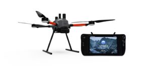
Pictured above: EasyOneLiDAR NDAA is integrated with a new ground control system.
EasyOneLiDAR NDAA features a new LiDAR sensor with 128 channels and Triple 1’’ cameras with mechanical shutters, providing RGB 60 MP combined resolution.
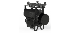
Pictured above: EasyOneLiDAR NDAA features a new LiDAR sensor with 128 channels and Triple 1’’ cameras with mechanical shutters, providing RGB 60 MP combined resolution.
Legrand concluded, “We are taking pre orders now, for delivery in October; interest has been high and we anticipate strong ordering activity in Q4 for this system. There is some pent up demand for something like this in the market.”
About Microdrones and GeoCue
Microdrones and GeoCue have joined together to bring geospatial experts the very best in drone surveying equipment, geospatial software, workflow, training and support for high accuracy LiDAR and drone mapping to help civil engineering and surveying professionals achieve successful data collection, processing, and management.
With TrueView drone LiDAR/Imaging sensors, LP360 point cloud data processing software, and fully integrated systems from Microdrones, we are the leader in LiDAR mapping processing in North America able to meet customers where they are in terms of technology adoption, budget, and resources.
To learn more about Microdrones, visit www.microdrones.com.
To learn more about GeoCue, visit www.geocue.com.
