Chesapeake Conservancy’s Data Science Team Publishes Article in “Science of the Total Environment”
Annapolis, MD – Chesapeake Conservancy’s data science team developed an artificial intelligence deep learning model for mapping wetlands, which resulted in 94% accuracy. Supported by EPRI, an independent, non-profit energy research and development institute; Lincoln Electric System; and the Grayce B. Kerr Fund, Inc., this method for wetland mapping could deliver important outcomes for protecting and conserving wetlands. The results are published in the peer-reviewed journal Science of the Total Environment.
The team trained a machine learning (convolutional neural network) model for high-resolution (1m) wetland mapping with freely available data from three areas: Mille Lacs County, Minnesota; Kent County, Delaware; and St. Lawrence County, New York. The full model, which requires local training data provided by state wetlands data and the National Wetlands Inventory (NWI), mapped wetlands with 94% accuracy.
“We’re happy to support this exciting project as it explores new methods for wetlands delineation using satellite imagery,” said EPRI Principal Technical Leader Dr. Nalini Rao. “It has the potential to save natural resource managers time in the field by using a GIS tool right from their desks. Plus, it can help companies and the public manage impacts to wetlands as infrastructure builds are planned to meet decarbonization targets.”
“The Infrastructure Investment and Jobs Act is pouring hundreds of billions of dollars into projects that will have an impact on the landscape. However, the data that we rely on to minimize impacts to wetlands is distressingly outdated,” said Environmental Policy Innovation Center’s Restoration Economy Center Director Becca Madsen, a former EPRI researcher. “There has never been a better time to invest in updating our nation’s wetland data and establishing a sustainable and cost-effective process for keeping them updated.”
“When this highly accurate model is scaled up to predict wetlands in much bigger geography such as the Chesapeake Bay or the contiguous United States, this will be a game changer. It obviates the need for manual mapping of wetlands as well as mapping wetlands with traditional machine learning which require a lot of data processing, curation and manual feature engineering, both of which are time-consuming, labor intensive and very expensive,” said Chesapeake Conservancy’s Data Science Lead/Senior Data Scientist Dr. Kumar Mainali.
What This Means for Protecting & Conserving Wetlands
The new model will help infrastructure planners avoid wetlands in the planning process, resulting in cost savings and wetlands conservation. Potential beneficial situations include ongoing efforts to expand and develop renewable energy, which requires expanding electric power infrastructure.
The product of the model is a map of wetland probability. This probability data may be used to map the most likely wetland extent, but if users prefer, they can map wetland extent with a lower probability threshold. The resulting map limits the likelihood of wetland omission even though it maps more wetlands than are present in reality.
There could also be potential to use this model to map locations where wetlands have already been lost since they were mapped with NWI. Additionally, potential locations for wetland restoration could also be identified. For example, persistently wet agricultural fields are picked up by the model even though for the purposes of field wetland delineation, these areas are not considered wetlands when actively farmed.
Next Steps
The team will expand the model to states or larger regions and continue to train the model on varied geographies.
Model Overcomes Outdated Data in Nebraska Pilot
Following the initial model development, the model was extended to include Lancaster County, Nebraska. Modeling wetlands in this region proved challenging because the NWI data for the area was decades out of date, and included wetlands in several areas where they had been lost to development. The team was interested to learn whether the model could succeed in mapping wetlands where no recent high-quality wetlands datasets were available to train the model.
The wetland model was trained with the decades-old NWI dataset and recent satellite and aerial imagery data. The team found that the NWI data improved the local accuracy of wetland mapping by 10% compared to predictions before training, showing the importance of using local training data in new geographies. In addition, the model correctly omitted wetlands where they had been lost to development, despite these wetlands remaining in the outdated training data, as shown in the image below (outdated training data shown in green; model prediction in purple, overlaid over recent satellite imagery). The performance of the model in determining the dominant pattern in the data to both improve local mapping accuracy but still accurately reflect wetland presence and absence is promising for the usefulness of this approach.
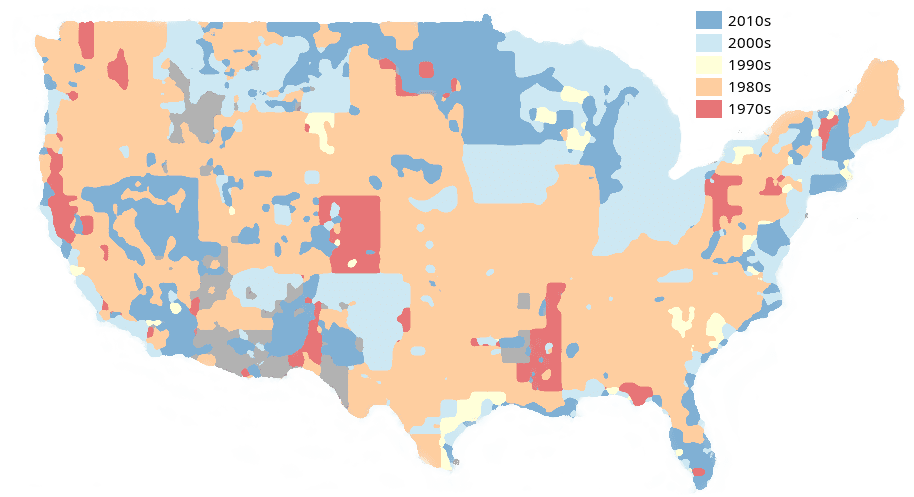
Despite the important role of wetlands data for planning infrastructure projects and managing wildlife, NWI wetlands data have not been comprehensively updated for many years. As shown in the map below, much NWI data across the nation dates to the 1970s and 1980s, yet remains the best available data. A modeling approach to wetland mapping that can utilize training data of varying vintages will be incredibly useful in modernizing wetland mapping where it is most needed. (For more information, see “It’s Time to Invest in a Modern Map of Our Nation’s Wetlands”: https://www.policyinnovation.org/blog/investing-in-a-modern-map-of-our-nations-wetlands)
About the Model
The “predictor” layers used in wetland training from which the model learns the patterns found in wetlands were: USDA National Agriculture Imagery Program (NAIP) aerial imagery (1m), Sentinel-2 optical satellite imagery (10-20m), LiDAR-derived geomorphons, an approach to mapping landforms that Chesapeake Conservancy has been applying to advance high-resolution stream mapping; and LiDAR intensity, an index that is frequently used to identify water and persistently wet soils.
Additionally, the team trained a simpler model using only USDA NAIP and Sentinel-2 data as the input layers, securing an accuracy of 91.6%.
The coauthors of the paper are Chesapeake Conservancy’s Data Science Lead/Senior Data Scientist Kumar Mainali, Ph.D., Senior Data Scientist Michael Evans, Ph.D., Geospatial Technology Manager Emily Mills (formerly with Chesapeake Conservancy), Senior Geospatial Technical Lead David Saavedra, Vice President of Climate Strategy Susan Minnemeyer, and former EPRI Project Manager Becca Madsen, now with the Environmental Policy Innovation Center.
Read the publication “Convolutional Neural Network for High-Resolution Wetland Mapping with Open Data: Variable Selection and the Challenges of a Generalizable Model” online in Science of the Total Environment.
For more information, see digital StoryMap, “Identifying Wetlands with Deep Learning: How an EPRI & Chesapeake Conservancy Collaboration Is Refining Desktop Wetland Identification for Improved Planning.”
The Chesapeake Conservancy’s Conservation Innovation Center (CIC) was established in 2013 to use cutting-edge technology to empower data-driven conservation and restoration. Just as the use of technology changed the corporate world and made it more efficient, technology can do the same for the conservation movement as the Chesapeake region and the nation adapts to rising seas and climate change and with global calls to protect 30% of land by 2030 as a climate solution. Through national and international partnerships, the CIC makes this data accessible for restoration professionals to practice precision conservation, yielding greater impact with fewer resources.
www.chesapeakeconservancy.org/conservation-innovation-center
Chesapeake Conservancy’s mission is to conserve and restore the natural and cultural resources of the Chesapeake Bay watershed for the enjoyment, education and inspiration of this and future generations. We empower the conservation community with access to the latest data and technology. We partnered to help create 206 new public access sites and permanently protect some of the Bay’s special places like Werowocomoco, Blackwater National Wildlife Refuge, Harriet Tubman Underground Railroad National Historical Park, Mallows Bay National Marine Sanctuary, Fort Monroe National Monument, Elktonia Beach and Pissacoack along Fones Cliffs on the Rappahannock River. www.chesapeakeconservancy.org
Founded in 1972, EPRI is the world’s preeminent independent, non-profit energy research and development organization, with offices around the world. EPRI’s trusted experts collaborate with more than 450 companies in 45 countries, driving innovation to ensure the public has clean, safe, reliable, affordable, and equitable access to electricity across the globe. Together, we are shaping the future of energy. www.epri.com
The mission of the Environmental Policy Innovation Center – EPIC – is to build policies that deliver spectacular improvement in the speed and scale of conservation. We believe that innovation and speed are central to broadening efforts to conserve wildlife, to restore special natural places, and to deliver people and nature with the clean water they need to thrive. To achieve those goals, conservation programs must evolve to accommodate our modern understanding of human behavior and incentives, and the challenges posed by humanity’s expanding footprint. www.policyinnovation.org
