DENVER, Colorado, USA – LAND INFO Worldwide Mapping LLC, the premier provider of mapping solutions for 5G wireless in North America, recently completed up-to-date 10m resolution thematic raster GIS data covering all 50 U.S. states. Optimized for low-band (broad-area coverage) 5G wireless planning, the dataset supports additional applications including utilities, insurance and government, and complements LAND INFO’s 1m resolution datasets that are used for mid-band and high-band 5G in more densely populated areas.
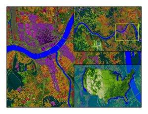
10m clutter (land-use/cover) mapping recently completed by LAND INFO for the entire USA; inset shows Cincinnati, Ohio.
“The dataset is unique in that in addition to using 2020-2021 Sentinel imagery and numerous ancillary layers, we were able to create best-in-class mapping by incorporating into our processing aerial-derived Digital Surface Model (DSM) elevation data via our longstanding partnership with Hexagon’s HxGN Content Program,” said LAND INFO president Nick Hubing.
The HxGN Content Program offers high-resolution, countrywide aerial imagery and elevation data of the contiguous United States and Western European countries. Hexagon continuously advances the program with higher resolution products for digital twin initiatives.
“We are proud to support LAND INFO’s land-use/cover mapping solution with our high-quality DSMs,” says John Welter, President, Geospatial Content Solutions at Hexagon. “LAND INFO is a well-established partner of Hexagon, and the partnership enables various industries to gain real-world analytics for reliable insights and better-informed decision making.”
LAND INFO’s proprietary automated geospatial processing technologies include object-based image analysis and artificial intelligence where smart rulesets analyzed, classified, and merged the imagery, DSM and ancillary layers into a single information rich dataset. There are currently just over 20 classes, and additional classes can be added upon request.
About LAND INFO
Founded in 1993, LAND INFO is unique for using both aerial and satellite remote sensing to custom create geodata solutions optimized for specific vertical market applications worldwide. The company’s significant investments in automated mapping technologies, including Object Based Image Analysis and Artificial Intelligence, allow it to offer competitive pricing, fast turnaround time and industry-leading quality to support large projects. Visit www.landinfo.com for more information.
