Demos at GeoWeek in Denver
COPENHAGEN – Phase One, a leading developer of digital imaging technologies, has announced its new iX Suite, a fully integrated software package for aerial mapping project management. Compatible with all Phase One PAS airborne systems, iX Suite handles mission planning, flight management, data acquisition, image selection and processing and in a common workflow.
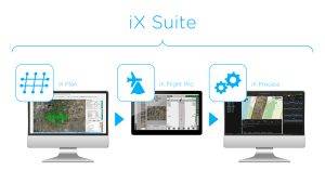
Phase One iX Suite software – from flight planning to final image delivery.
Phase One will demonstrate the iX Suite in Booth #320 at GeoWeek 2022 being held February 6-8 in Denver, Colorado.
“We developed the iX Suite for efficient collection and delivery of high-quality aerial image products,” said Oodi Menaker, Phase One iX Suite Product Manager. “Every step of the workflow is planned and executed to ensure mapping projects are completed on time and on budget.”
With the iX Suite, Phase One has taken a novel approach to managing aerial mapping projects by making quality control a key focus throughout the workflow to guarantee the generated image products meet end user specifications. A unique aspect of the iX Suite workflow is that imagery can be reviewed inflight and re-collected immediately if necessary, reducing the need for budget- and schedule-killing re-flights days or weeks later.
The iX Suite is comprised of three software tools that automate many functions to reduce workloads for pilots and operators in the air and streamline processing activities for technicians on the ground. These three software components are:
iX Plan is a 3D photogrammetric flight planning application that takes end user requirements, terrain, and sensor properties into account to chart flightlines. The software includes a sensor database containing details of all Phase One PAS cameras and LiDAR sensors so that each image and point cloud acquisition is planned with exact area coverage, overlap, and resolution.
iX Flight Pro is the flight and sensor management application that guides the pilot through the flight and triggers acquisition of sensor data. Images are displayed and overlaid on digital terrain model (DTM) in the graphical user interface so the onboard operator can view their quality and confirm precise coverage of the AOI.
iX Process is an all-in-one mission review, quality assurance, and image export application. Using the mission report generated by iX Flight Pro, the processing tool overlays captured images on the flightline map and 3D DTMs, allowing the photogrammetric technician to check again for data quality and precise coverage of geographic areas. Accepted data sets are processed to generate and export images in commercial formats for delivery to end users.
“The iX Suite is tightly coupled with Phase One sensors, making our PAS aerial mapping systems easier, more intuitive, and cost-effective to operate,” said Menaker. “Also, iX Suite interfaces with Riegl LiDAR systems, enabling customers to simultaneously operate a Phase One PAS camera and Riegl LiDAR with one management software in flight.”
The Phase One PAS line of sensor systems was designed specifically to address the challenges of aerial image acquisition for 2D and 3D city modelling, photogrammetric mapping and surveying, agriculture, and other geospatial applications. The PAS product line includes the five-camera PAS 880 oblique and nadir system, PAS 280 large-format system, and PAS 150 systems.
Learn more at https://phaseone.ws/iX-suite
Watch the video: https://phaseone.ws/ix_suite_youtube
About Phase One
Phase One A/S is a leading researcher, developer and manufacturer of medium format and large format digital cameras and imaging Systems.
Founded in 1993, Phase One is a pioneer of digital photography. Phase One has developed core imaging technologies and a range of digital cameras and imaging modules, providing the world’s highest image quality in terms of resolution, dynamic range, color fidelity and geometric accuracy. As such, Phase One has grown to become the leading provider of high-end imaging technology across many demanding business segments, such as aerial mapping, industrial inspection and cultural heritage digitization, as well as serving the world’s most demanding photographers.
Based in Copenhagen, Denmark, and with regional offices in New York, Denver, Cologne, Tel Aviv, Tokyo, Beijing, Shanghai and Hong Kong, Phase One nurtures long-term relationships with customers, technology partners and its global network of distributors, often playing the role of digital imaging partner to customers with special requirements. It is with this passion for service that Phase One continually exceeds expectations and drives the imaging industry forward.
