GOLDEN, Colorado – Golden Software, a developer of affordable 2D and 3D scientific modeling packages, has enhanced the map-making functionality and data exporting capabilities in the latest version of its Surfer surface mapping package.

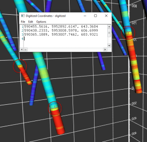
Get more information from 3D models in Surfer by digitizing XYZ coordinates of spot locations.
“In this version, we focused on making it easier and faster for Surfer users to create the maps they envision without time-consuming workarounds or using other software,” said Kari Dickenson, Surfer Product Manager. “Surfer makes it easier to export data and grid files to a GIS or CAD package.”
The Surfer surface mapping software is used by more than 100,000 people worldwide, many involved in oil & gas exploration, environmental consulting, mining, engineering, and geospatial projects. The software has been relied upon for more than 30 years by users in numerous disciplines to easily visualize and interpret complex data sets.
Known for its fast and powerful contouring algorithms that regularly outperform more expensive packages, Surfer enables users to model data sets, apply an array of advanced analytics tools, and graphically communicate the results in ways anyone can understand.
Golden Software has made the following enhancements in the latest Surfer version released today:
Scale Bars and Color Bars now have frames with outlines and background fill colors to make them more aesthetic and easier to read when placed on top of maps. Previously, this was a time-consuming multi-step process in which the user had to draw polygons and place them behind the scale and color bars.
3D Surface Map in 2D Plot Window allows the user to fill the sides of the 3D surface layers down to a customized Z value. This is especially useful when overlaying surface maps to create a block model, so the user can fill the side down to any value, including zero, instead of the grid minimum.
Attribute Data can now be exported as numeric data. In the past, Surfer converted numbers to text when saving the worksheet to a DBF or when exporting base layers to SHP/DBF or data files. Numeric values are now retained during both exporting functions.
Grid Files can be saved as GeoTIFFs, or Tagged Image File Format, which allows for easy data compatibility with other software packages such as ArcGIS, QGIS, Global Mapper, and USGS DEM File Reader.
Digitizing in the 3D View allows the user to click on spot locations on drillhole paths, surface layers and other features in the 3D View and capture the X, Y and Z coordinates of the locations clicked.
Info Page in Properties for Grid-Based Layers is updated to display commonly used information about the grid file used to create the layer, such as information about the file itself, the XY geometry, and Z statistics. This information previously could only be obtained through a multi-step reporting process.
Surfer Beta Available
As is the tradition, Golden Software has released a Beta version of Surfer simultaneously with the new version to give customers a chance to try out new features while they are still in development. Users may find the Beta version by clicking File | Online from within Surfer.
“We are making it easier to edit vector and grid files in the Beta capabilities now available,” said Dickenson.
Here are the new features available in Beta now, to be officially included in the Spring 2022 release of Surfer:
About Golden Software
Founded in 1983, Golden Software is a leading developer of affordable scientific graphics software. Its customer base includes over 100,000 users involved in environmental consulting, oil and gas exploration and extraction, mining exploration and extraction, engineering, applied science, business, education, and government in nearly 190 countries and territories. Golden Software offers four products: Surfer® for gridding, contouring and 3D surface mapping; Grapher™ for 2D and 3D graphing; Voxler® for 3D data visualization; and Strater® for well log, borehole and cross section plotting.
For additional information, visit www.GoldenSoftware.com or call 1-303-279-1021