Plex-Earth, a full-blown popular platform for AutoCAD that brings the world’s largest aerial and satellite imagery providers under a single umbrella, now expands its offering to BricsCAD, to inform smart engineering with recent, historical, high-quality imagery and terrain data.
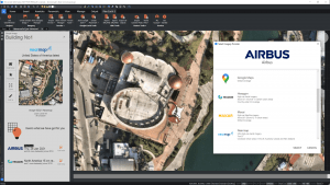
By leveraging the power of premium imagery from leading providers like Maxar, Airbus, Nearmap, Hexagon or Google Maps within BricsCAD and visualizing designs into Google Earth, engineers understand project site conditions early on, speed up processes and avoid rework.
The ability to rapidly and easily obtain quality real-world data remotely with Plex-Earth, is of utmost importance especially in light of the coronavirus pandemic, where site visits and ground-based surveys are limited or not possible.
Instead of using free imagery sources that are often outdated and unsuitable for commercial engineering use, designers can make full use of Airbus’ and Maxar’s vast historical datasets or Nearmap’s and Hexagon’s ultra-high resolution imagery to get better precision and track the progress of their projects.
“Ten years ago, being a civil engineer myself, I got a bitter taste of the true cost of rework, leading me to develop a tool that would give me a bird’s eye view of the jobsite and ultimately make me a better engineer. Plex-Earth was born back in 2010 out of this necessity and I am truly excited that we have now expanded our unique offering to BricsCAD and businesses of any size through a variety of affordable Plex-Earth subscriptions. New content providers will constantly be added and we will soon also include on-demand drone flights in the mix”, said Lambros Kaliakatsos, Plexscape founder and CEO.
With Plex-Earth’s unique business model, individual engineers, small or large businesses can all have access to premium content from within their preferred CAD environment, for a flat subscription fee and at no extra cost without the need to seek individual companies and commit to large contracts. A fully-functional free trial of Plex-Earth is available at https://plexearth.com/free-trial.
About Plexscape
Plexscape is a software company committed to changing the way engineers work on Architectural, Engineering, and Construction (AEC) projects, by developing innovative solutions that bridge the gap between design and the real world.
Our award-winning team (and Autodesk Authorized Developer since 2010) is proud to have created Plex-Earth, a full-blown platform that brings the world’s largest aerial and satellite imagery providers like Maxar, Airbus, Nearmap, Hexagon and Google Maps together under a single umbrella, to give engineers easy access to recent and historical high-quality imagery and terrain data right from within their CAD environment.
By also connecting AutoCAD and BricsCAD to Google Earth to facilitate 2D and 3D real-world visualization, AEC designers get a complete understanding of their project sites’ conditions from the very beginning of their workflow, speed up processes and avoid the high cost of rework by reducing errors.
For more information on Plex-Earth visit www.plexearth.com
