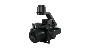
COPENHAGEN – Phase One, a leading developer of digital imaging technologies, today announced the P3 Payload, a versatile solution designed for fast, efficient, and safe inspection of critical infrastructure with an Unmanned Aerial Vehicle (UAV). The P3 Payload includes a Phase One iXM 100MP or 50MP camera, one of the RSM lens options, and a new gimbal with integrated rangefinder.
Available in Q2 2021, the P3 Payload is extremely versatile, offered in two configurations to meet a wide range of user requirements. The P3 for the DJI M300 is plug-and-play and ready to fly with a M300 drone, developed mainly for operators and service providers that already own, or are considering purchasing, a DJI M300. The P3 MAVLink is ready for integration with the many drones that are based on the open-source MAVLink protocol, ideal for bundling by OEMs and solution integrators.
“The P3 addresses the unmet need for a high-quality, integrated imaging solution for inspection of critical assets where capturing the details is of paramount importance,” said Michael Messerschmidt, Portfolio Director for Drones & Inspection. “The P3 Payload is designed specifically for aerial drone inspection of diverse infrastructure where every flight – and every shot – must count.”
The centerpiece of the payload is the customer’s choice of best-in-class Phase One iXM 100MP or 50MP camera. Robust and waterproof, these sensors boast a dynamic range that guarantees sharp image collection in high-contrast or low-light environments. The variety of lens options ensures large surface areas can be captured with millimeter-level detail – even at safe distances from the asset. The new gimbal with the integrated laser rangefinder ensures precise and fast focusing on every shot, eliminating blurry and out-of-focus images.
“We developed the P3 Payload for cost-effective, productive operation so that large surface areas can be covered in fewer images, significantly shortening the mission time,” said Michael Messerschmidt. “More importantly, the P3 can be operated with minimal risk to the asset and ground crew.”
The P3 Payload will deliver productive results and prove its versatility in these diverse inspection applications:
High Value Assets – Bridges, dams, energy facilities where the value of the structure itself is high and the demand for frequent, accurate, and detailed data is critical.
High Risk Assessment – Electric transmission lines, oil refineries, and other complex sites where inherent danger requires high-resolution inspection from a distance that is safe for the structure, the drone and personnel.
Time Critical Assets – Wind turbines, offshore oil rigs, and other facilities where inspection windows are limited, and every UAV flight must successfully capture the required information.
The Phase One P3 Payload is a turnkey solution to handle all your UAV inspection needs.
For more information, visit https://geospatial.phaseone.com/drone-payload/p3-payload-for-drones/
About Phase One
Phase One A/S is a leading researcher, developer and manufacturer of medium format and large format digital cameras and imaging Systems.
Founded in 1993, Phase One is a pioneer of digital photography. Phase One has developed core imaging technologies and a range of digital cameras and imaging modules, providing the world’s highest image quality in terms of resolution, dynamic range, color fidelity and geometric accuracy. As such, Phase One has grown to become the leading provider of high-end imaging technology across many demanding business segments, such as aerial mapping, industrial inspection and cultural heritage digitization, as well as serving the world’s most demanding photographers.
Based in Copenhagen, Denmark, and with regional offices in New York, Denver, Cologne, Tel Aviv, Tokyo, Beijing, Shanghai and Hong Kong, Phase One nurtures long-term relationships with customers, technology partners and its global network of distributors, often playing the role of digital imaging partner to customers with special requirements. It is with this passion for service that Phase One continually exceeds expectations and drives the imaging industry forward.
Learn more at https://geospatial.phaseone.com
