AARSCHOT, Belgium, 8 September 2020 – In release 7.4, Virtual Surveyor has added new functionality to the free pricing level of its popular drone surveying software. The “Valley” plan of Virtual Surveyor now allows users to create engineering CAD models from drone orthophotos and/or LiDAR data sets.
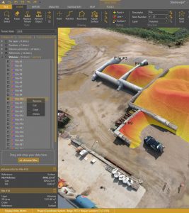
Renaming a stockpile through the new right-click menu
“Originally offered as a free viewing tool for imagery and elevation models captured by unmanned aerial vehicles (UAVs), our Valley software plan now enables surveyors to create topographic line surveys for small-area projects,” said Tom Op ‘t Eyndt, Virtual Surveyor CEO.
Available under three pricing plans, the Virtual Surveyor software enables surveyors to derive topographic information from drone data that engineers need for construction, mining, and other excavation projects. The software has become popular among surveyors and engineers because its tools allow them to work effectively with drone data.
Virtual Surveyor generates an interactive onscreen environment where the surveyor selects survey points and breaklines to create a highly accurate lightweight CAD model for further use in engineering design packages. When the surveyor wants to calculate volumetric change directly in Virtual Surveyor using all data points, like stockpiles or a cut/fill map, the software creates a clean terrain model to remove conveyors and machines through simple clicking.
In addition to upgrading the free Valley plan, Virtual Surveyor 7.4 has changed the names and enhanced capabilities of its other purchase plans. The three plans are:
Valley (Free) – Create CAD models from drone images or LiDAR for topographic surveying applications in small areas.
Ridge – Create advanced topographic and quantity surveys, including digital surfaces and contours, as well as stockpile volume calculations, from drone data for advanced surveying projects.
Peak – Designed for large-area projects, this plan includes Productivity Tools, such as intelligent gridding and guided breakline generation that speed processing. Most importantly, Peak enables surveyors to measure and track cut-and-fill progress at construction, mining, and other excavation sites over time.
“All Virtual Surveyor plans now empower surveyors to extract meaningful topographic information from their drone data,” said Op ‘t Eyndt.
Virtual Surveyor 7.4 also includes other functionality improvements that span all three pricing levels, making the software faster and easier to use. Most notably, users can now easily rename layers and items, and move items between layers through drag-and-drop. Download the free Valley application today and see what else is new in the Virtual Surveyor smart drone mapping package.
Current subscribers to Virtual Surveyor will see their software being updated to Version 7.4 automatically. To start a free 14-day trial of Virtual Surveyor and to view details of the three pricing plans, visit www.virtual-surveyor.com.
About Virtual Surveyor
Virtual Surveyor software enables professional surveyors to generate accurate topographic end products from drone imagery five times faster than traditional field work. Now used in 68 countries, Virtual Surveyor allows surveyors to topographic information from drone data in very short timeframes. In a typical application, the suite takes the orthophotos and digital surface models (DSM) extracted from UAV imagery with photogrammetric software like Pix4D, Metashape or DJI Terra and generates an interactive virtual environment onscreen where surveyors can select the survey points and breaklines that define topography. Standard topographic outputs from the Virtual Surveyor software are Surfaces or TINs (Triangular Irregular Network), Contours, Line Surveys and Cut-and-Fill Maps. As such, Virtual Surveyor bridges the gap between UAV photogrammetric processing software and engineering design packages.
