Trimble R12i GNSS Receiver Incorporates Robust Tilt Compensation to Increase Productivity for Land Surveyors
SUNNYVALE, Calif.—Trimble (NASDAQ: TRMB) introduced today the Trimble® R12i GNSS receiver, the latest addition to its Global Navigation Satellite System (GNSS) portfolio. The Trimble R12i incorporates Inertial Measurement Unit (IMU)-based tilt compensation using Trimble TIP™ technology, which enables points to be measured or staked out while the survey rod is tilted, empowering land surveyors to focus on the job at hand and complete work faster and more accurately.
The IMU-based tilt compensation capability of the Trimble R12i builds on Trimble’s unrivaled ProPoint™ GNSS positioning engine, which delivers more than 30 percent better performance in challenging environments compared to the Trimble R10-2 receiver across a variety of factors, including time to achieve survey precision levels, position accuracy and measurement reliability. Designed with flexible signal management that enables the use of all available GNSS constellations and signals, the Trimble ProPoint GNSS engine provides new levels of reliability and productivity. In addition, the ProPoint engine is a key enabler of the new TIP technology. Surveyors can continue to use the R12i’s tilt compensation functionality even in challenging environments when other solutions struggle to maintain GNSS and inertial positioning.
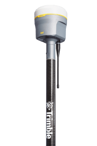
The Trimble TIP technology allows users to accurately mark and measure points in areas previously inaccessible for GNSS rovers such as building corners, or in hazardous situations, for example the edge of an open excavation. The receiver operates calibration-free out of the box and is resistant to magnetic interference from sources such as cars or electrical utility boxes. The R12i also features real time automatic Inertial Navigation System (INS) integrity monitoring. This system allows users to detect and correct for IMU biases introduced by use over time, temperature or physical shocks helping ensure measurement quality and integrity for the life of the receiver.
“The R12i represents Trimble’s dedication to perfecting the user experience with the industry’s best GNSS engine and now robust tilt compensation,” said Ron Bisio, senior vice president of Trimble Geospatial. “Trimble has been the leader in GNSS technology for more than 30 years and the R12i demonstrates our continued commitment to providing surveyors with the world’s most advanced and trusted GNSS systems.”
Availability
The Trimble R12i GNSS System is available now through Trimble’s Geospatial distribution channel. For more information, visit: https://R12i.trimble.com.
About Trimble Geospatial
Trimble Geospatial provides solutions that facilitate high-quality, productive workflows and information exchange, driving value for a global and diverse customer base of surveyors, engineering and GIS service companies, governments, utilities and transportation authorities. Trimble’s innovative technologies include integrated sensors, field applications, real-time communications and office software for processing, modeling and data analytics. Using Trimble solutions, organizations can capture the most accurate spatial data and transform it into intelligence to deliver increased productivity and improved decision-making. Whether enabling more efficient use of natural resources or enhancing the performance and lifecycle of civil infrastructure, timely and reliable geospatial information is at the core of Trimble’s solutions to transform the way work is done. For more information, visit: https://geospatial.trimble.com.
About Trimble
Trimble is transforming the way the world works by delivering products and services that connect the physical and digital worlds. Core technologies in positioning, modeling, connectivity and data analytics enable customers to improve productivity, quality, safety and sustainability. From purpose built products to enterprise lifecycle solutions, Trimble software, hardware and services are transforming industries such as agriculture, construction, geospatial and transportation. For more information about Trimble (NASDAQ:TRMB), visit: www.trimble.com.
GTRMB
