Asian Surveying & Mapping
Breaking News
HAL to build, market Isro’s SSLV in landmark deal
New Delhi, Jun 20: In a historic move for...
Taiwan developing space capabilities for all-weather imaging
TAIPEI (TVBS News) — Taiwan is advancing its space...
Honda hails successful test of reusable rocket as it looks to get into the space business
Tokyo — Japan's second-biggest carmaker, Honda, has successfully tested...
China’s space program provides larger platform for broader international cooperation
BEIJING -- Experts from China's manned space program said...
India To Launch $1.5 Billion Joint Earth Mission With NASA In July
National Aeronautics and Space Administration (NASA) and the Indian...
Axiom-4 mission delayed again: ISRO confirms Subhanshu Shukla’s ISS spaceflight won’t launch before 22 June 2025
The Axiom-4 mission to the International Space Station has...
Mengzhou spacecraft for China’s moon-landing mission passes landmark test flight
China has completed the inaugural test flight of its...
Space application for ITMA Asia + CITME 2026 opens
Shanghai – Space application for the 2026 edition of...
Yanmar, Chia Tai and XAG Empower Thai Agriculture through Innovation
Bang Nam Priao District, Chachoengsao Province, Thailand – On...
bitsensing Signs MOU with IKIO Technologies to Advance AI-Based Traffic Monitoring on India’s Expressways, Highways and Municipal Areas
Backed by proven success in South Korea and Europe,...

July 31st, 2020
Population Projections (2020-2100, USA) as KML, GeoJSON, Shapefile

NEWTON, MA (USA) – Maptitude U.S. County Projection Data 2020-2100 are available and includes 2,448 columns of nationwide cross-tabulated demographics by age, race, gender, and ethnicity.

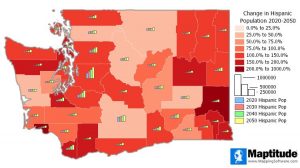
The new data allow you to target areas by growth using demographic forecasts by 5-year increments out to 2100. These detailed projections are perfect for site location, competitive analysis, marketing campaigns and any kind of analysis that involves considering future population counts. This wealth of data can be leveraged by marketers and business analysts using Maptitude mapping software, a comprehensive application for data exploration.

The County Projections data are free for Maptitude 2020 users, and are also available as shapefile, KML, KMZ, or GeoJSON for a fee. If you have any questions about Maptitude or data availability contact the Maptitude team.

About Caliper

Caliper Corporation develops state-of-the-art Geographic Information Systems (GIS) software. With a focus on usability, Maptitude is designed to be a cost-effective, professional mapping software product. Maptitude enables organizations to leverage their location-based data to improve decision making and planning, while minimizing expenditure through competitively priced solutions.

Caliper is a privately held corporation and is a leading developer of mappingredistrictingtransportation, and GIS software