
WASHINGTON, D.C., USA (23 June 2020) — Hexagon’s Geosystems division announced today the HxGN Content Program, the largest library of high-accuracy airborne data, is updating 3 million square kilometres in 2020 of high-accuracy four-band orthophotos, digital surface models (DSM) and stereo imagery across the United States and Europe.
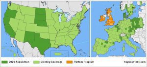
The HxGN Content Program will capture 3 million square kilometres of new four-band orthophotos, DSM and stereo imagery in 2020.
In North America, the HxGN Content Program will update 2.5 million square kilometres of aerial data, close to a third of the continental United States. This includes a refresh of previously captured states, such as California, Texas, Oregon, North Dakota, South Dakota, Nebraska and New Mexico. In Europe, more than 500,000 square kilometres of data will be collected. The refreshed data will be available before the end of 2020.
In addition to the standard 30-centimetre resolution in wide areas and 15-cm resolution in urban areas in the U.S., the 2020 program will include 15-cm resolution data in wide areas upon customer request. The Danish DDO program, the premier aerial data provider in Denmark, will also become part of the HxGN Content Program for the first time and will cover the country at 12.5-cm resolution on a biennial refresh schedule.
“The regular data refresh and the high accuracy standards make the HxGN Content Program an ideal, cost-effective solution for many industries. Depending on the application, users have slightly different data requirements. To meet these demands, we have now made our product offering more flexible,” said John Welter, President, Geospatial Content Solutions, Hexagon’s Geosystems division. “The automotive industry requires very high-resolution leaf-off data for street-level detail, while in telecommunications leaf-on data provides information for line-of-sight analysis for 5G network implementations. In the public sector, data needs depend on the urbanization rates of the area. Ultimately, we are a customer-driven program that provides data to enable informed decision-making.”
Enabling machine learning and AI applications
With a consistent and scalable high-resolution aerial imagery database, the HxGN Content Program offers large quantities of highly accurate and reliable data ideal to train machine learning algorithms that depend on steady streams of input to automatically recognize unique attributes. Artificial intelligence is used to automatically extract features in the data to provide valuable information across multiple applications, such as buildings, roads, railways, vegetation, solar panels and many more.
The HxGN Content Program achieves the needed consistent data for the algorithms by emphasizing repeatability in sensor technology, flight planning, acquisition parameters and processing techniques. Entire states and regions are collected in the same season to avoid a patchwork of irregular images. The multispectral source data is stored in a non-proprietary cloud optimized geo-tiff format ready for direct access.
About HxGN Content Program
Since its inception in 2014, the HxGN Content Program has collected 21.7 million square kilometres (8.3 million square miles) of 30-centimeter (1 foot) resolution aerial data and 815,000 square kilometres (315,000 square miles) of 15-cm (1/2 foot) data in urban centres. The program follows rigorous acquisition and processing standards to offer the highest positional accuracy for applications such as asset management, public safety, telecommunications network maintenance and installation, utility mapping, and property assessment. For consistency across the imagery, every state is captured in the same season, allowing to leverage the data organisation-wide. The orthophotos are available as RGB and near-infrared imagery via streaming subscription or as a download. Derivate data products, such as digital surface models (DSM) and stereo imagery, are available upon request, and Hexagon will keep updating its offering based on consumer needs.
About Hexagon
Hexagon is a global leader in sensor, software and autonomous solutions. We are putting data to work to boost efficiency, productivity, and quality across industrial, manufacturing, infrastructure, safety, and mobility applications.
Our technologies are shaping urban and production ecosystems to become increasingly connected and autonomous – ensuring a scalable, sustainable future.
Hexagon’s Geosystems division provides a comprehensive portfolio of digital solutions that capture, measure, and visualise the physical world and enable data-driven transformation across industry ecosystems.
Hexagon (Nasdaq Stockholm: HEXA B) has approximately 20,000 employees in 50 countries and net sales of approximately 3.9bn EUR. Learn more at hexagon.com and follow us @HexagonAB
