Every aviation operation wants to maintain a low risk profile, and corporate drone programs are no exception. But tracking and recording risk across distributed teams flying dozens of missions is a big challenge. That’s where Skyward’s Aviation Management Platform comes in. We help you manage all your drone flights, personnel, aircraft, and more.
And with our brand new risk assessment tool, we’re helping drone program managers proactively identify and document critical risks to an operation. It’s another key element in a complete digital system of record for your drone ops.
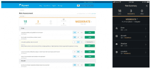
For assessing risk, we chose a method that’s both simple and effective. Using Skyward’s web or mobile apps, pilots and managers answer a series of risk questions developed by Skyward’s drone experts and based on aviation best practices.
Each answer is assigned a risk level: low, moderate, or high. As each question is answered, an overall risk summary score is generated based on the highest level of risk present — not complicated scoring formulas.
In addition, users can add mitigation for any risk level: just add an explanation and adjust the risk level. The mitigated risk will be noted in the summary, and the note will be synced across the Skyward software platform.
For a detailed look at Skyward’s risk assessment tool, visit the Risk Assessment page on the Skyward User Guide. To try out these new features, visit the web app or log into InFlight. If you aren’t a Skyward subscriber, see how Skyward’s Aviation Management Platform can help your drone program improve airspace intelligence, safety, and efficiency.
As a drone program manager, you want your operations to be safe from start to finish. Skyward’s risk assessment helps pilots address the fundamentals of risk management before they fly, and it provides managers a record of the organization’s risk profile. Along with our new Live Flights feature, Skyward is raising the level of operational oversight and program management for enterprise drone programs.
By Amanda Breese
Product Manager
Skyward, A Verizon company
