
Indoor location platform provides municipalities with emergency response and public safety solutions on existing WiFi networks
TORONTO (ON) MARCH – InnerSpace, the world’s most accurate WiFi-based indoor location intelligence platform, today announced its product capabilities to support all levels of government to analyze the patterns and movement in public spaces using existing WiFi networks. The platform is ideally suited to understand the movement of people inside public spaces and can support emergency response strategies, social distancing programs, and help Smart Cities implement effective security and public safety measures.
“In response to the global COVID-19 pandemic, we have accelerated the delivery of our public safety solution inFORCE,” said James Wu, CEO, InnerSpace. “Our platform processes RSSI data in real-time and returns the industry’s most accurate location data available today. By using public WiFi access points, municipalities have a way to quickly roll out new solutions at city-wide scale.”
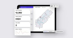
InnerSpace inFORCE, was selected in a competitive process by the Department of Homeland Security, for its ability to use WiFi to locate citizens and track emergency responders in an active shooter scenario. The same platform can be used in a wide variety of emergency situations such as the current COVID-19 pandemic. In addition to the company’s tracking capabilities, it’s analytics dashboard gives public safety offices an unprecedented view into how people leverage public spaces.
“In times of emergency, it is reasonable to prioritize safety and public health to minimize the loss of human life,” said Cerys Goodall, President & COO, InnerSpace. “By providing municipalities with a system that can deliver line-of-sight into how people move in public spaces, we can inform response strategies, improve rescue efforts, and create an infrastructure to support better outcomes.”
InnerSpace inFORCE ingests RSSI data and returns accurate anonymous indoor locations. The information can be connected directly into emergency response communications systems, building management and security systems, or analyzed by InnerSpace to identify critical patterns and trends in people’s movements.
About InnerSpace
InnerSpace is on a mission to become the world’s leading indoor location platform. Delivering the most accurate WiFi-based indoor location data, the company gives clients unparalleled value with its easy-to-use API, out-of-the-box analytics, and workflow initiation solutions. The company’s Fortune 500 clients use InnerSpace to create innovative solutions that drive revenue and improve operations in their Smart Buildings. Innerspace.io
