Singapore Land Authority (SLA) has announced the launch of 3D Singapore Sandbox, a first-of-its-kind collaborative environment for technology industry partners and developers. This initiative aims to encourage the use of 3D city models and geospatial data to develop and test new applications and services that can benefit both the public and private sectors.
The 3D Singapore Sandbox is open to industry partners who wish to leverage on 3D geospatial data to support better decision-making, and to develop smart solutions to drive operational efficiencies and value for business end-users.
“We believe the global geospatial industry is set to undergo a major transformation from 2D to 3D in the coming years. By making available 3D city models that we have built, as well as other geospatial data through the Sandbox, we hope innovators, entrepreneurs, industry partners and the technology community can develop and test new services and solutions that will add to Singapore’s effort in becoming a smart city,” said SLA GeoSpatial & Data Director and Chief Data Officer, Ng Siau Yong.
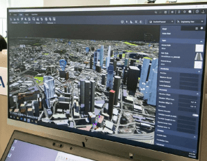
The sandbox will provide users with access to SLA’s 3D geospatial data including 3D models of over 160,000 buildings mapped nationwide. Users will also have access to geospatial solutions provided by established industry partners Autodesk, Bentley Systems, Esri Singapore and Hexagon Geospatial. On top of that, SLA has collaborated with global data analytics provider LOTaDATA to provide access to “people movement intelligence” data for geo-analytics. LOTaDATA, short for “lot of data” is a San Francisco-based GovTech company.
According to Apu Kumar, CEO of LOTaDATA, the startup invented ‘People Intelligence’ in 2017. “Our accurate, anonymised, daily crowdsourced mobile datasets about people-presence, activity, and movement, are available for 1450 cities and metro areas worldwide. By joining forces with SLA, we have made our datasets accessible to the geospatial community to solve real-world problems ranging from urban planning, mobility, transportation, economic development, public health, and disaster resilience.”
Businesses in the architecture, real estate, construction and logistics industries are identified as potential first movers. They are encouraged to leverage on the sandbox to collaborate with industry partners to co-create and develop innovative solutions to enhance their business operations and processes. For example, real estate developers could use the sandbox’s 3D geospatial data, models, and tools to visualise how their new building construction would synergise with the surrounding urban environment to improve overall livability for the neighbourhood.
The sandbox is located at GeoWorks, the geospatial industry centre first set up by the SLA in 2018 to promote business growth, drive innovation and foster a well-connected community of geospatial firms.
GeoWorks currently hosts 42 companies, otherwise known as GeoMembers, which consist of a combination of geospatial scale-ups and large established geospatial organisations. These GeoMembers come together to share and build expertise, network access, and business opportunities for the whole geospatial industry.
Businesses interested to use the 3D Singapore Sandbox can visit www.geoworks.sg for more information.
