(HEERBRUGG, Switzerland, 10 March 2020) – Leica Geosystems, a Hexagon company, today announced to further develop its one-for-all Leica MC1 3D machine control platform with the new Leica iCON grade solutions for dozers and motor graders. The new MC1 platform will precisely and safely control dozers and motor graders automatically and assist operators to meet the exact grade on any given surface while reducing operator fatigue.
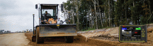
Leica iCON grade solutions for dozers and motor graders
Further growing its construction portfolio of easy-to-use, interoperable and easy-to-integrate products, Leica Geosystems will allow dozer and motor grader operators to work faster, safer and more accurately while continuously sharing real-time data between field and office. Users can leverage the same interchangeable MCP80 panel to run the new MC1 3D machine control software as an intuitive all-in-one system for dozers and motor graders.
Operators can benefit from simple 1D and 2D solutions with new and improved Leica MLS820
laser receiver sensor for dozers and Leica MUS1400 trisonic sensor for graders. Customers can upgrade easily to 3D when the job site requires more automation, documentation or higher accuracy.
“With the new introduction of dozers and motor graders on one common hardware and software platform, we are proud to present the most flexible grading machine control solution on the market. Our solutions offer a modular approach that allows customers to quickly change the configuration, including single, dual GNSS, TPS, on-cab or blade-mounted antennas; without changing cabling and sensors,” explained Kris Maas, director of product management of machine control at Leica Geosystems. “We provide full flexibility for our customers to adapt to multiple job situations quickly.”
Digitised workflows in real time
The Leica iGD3 for dozers and iGG3 solution for motor graders interface seamlessly with Leica ConX, providing one single hub for sharing project files. Configurable auto-logging of as-built points under the blade can be shared with ConX continuously and the new productivity tool allows for analysing and monitoring project progress and volume calculations in real time.
Both innovations are available for hands-on demonstrations at CONEXPO-CON/AGG 10-14 March 2020 in Las Vegas, United States, on the Hexagon Booth in North Hall, at stand #N-12166.
Leica Geosystems – when it has to be right
With more than 200 years of history, Leica Geosystems, a Hexagon company, is the trusted supplier of premium sensors, software and services. Delivering value every day to professionals in surveying, construction, infrastructure, mining, mapping and other geospatial content-dependent industries, Leica Geosystems leads the industry with innovative solutions to empower our autonomous future.
Hexagon is a global leader in sensor, software and autonomous solutions. We are putting data to work to boost efficiency, productivity, and quality across industrial, manufacturing, infrastructure, safety, and mobility applications.
Our technologies are shaping urban and production ecosystems to become increasingly connected and autonomous — ensuring a scalable, sustainable future.
Hexagon (Nasdaq Stockholm: HEXA B) has approximately 21,000 employees in 50 countries and net sales of 3.9bn EUR. Learn more at hexagon.com and follow us @HexagonAB.
