Heerbrugg, Switzerland – Leica Geosystems, part of Hexagon, announced today the Leica Zeno Mobile data collection app now integrates HxGN SmartNet post-processing service and Esri’s Geospatial Cloud, a leading provider of Geographic Information Systems (GIS). The new functionalities allow workforces with limited surveying knowledge to optimise data accuracy and precision in the field and office and enable a seamless data flow to Esri’s GIS products.
Leica Zeno Mobile integrates HxGN SmartNet post-processing service and Esri’s Geospatial Cloud
Thanks to HxGN SmartNet, Zeno delivers high accuracy RTK positioning. In areas without internet connection, Zeno Mobile’s new automatic post processing service allows users not to have to worry whether they have a mobile internet connection or not. In areas without internet connection, Zeno Mobile records all the raw GNSS measurements. When the internet connection is restored, raw data is processed in HxGN SmartNet’s new cloud service, which is now seamlessly integrated in Zeno Mobile. Measurements previously taken without RTK are improved to high accuracy, directly on the mobile device. Post processing is simplified as additional software or specific knowledge is no longer needed.
“Capturing data has never been easier. With the latest version of Zeno Mobile, data is always accurate, no matter if there’s an internet connection or not. Thanks to the new Esri connectivity, data collected in the field is now synchronised on the fly with our GIS database. By simplifying processes and automating tasks our workforce is able to spend more time on new projects and accelerate our business.” Matthias Beisswenger, project manager surveying at GEO DATA GmbH.
Simplifying data flow processes
Zeno Mobile enriched its data flow capability and simplified the data exchange to Esri products. Through Esri’s Geospatial Cloud integration, a seamless connection between Zeno Mobile and Esri’s ecosystem allows users to benefit from a completely remote data flow from office to field and back.
Layers, data and roles can be defined directly in the browser through ArcGIS Online or in Esri’s Desktop software. Once the data is shared through the cloud, workforce can start data acquisition in Zeno Mobile and synchronise it back to the office instantly. The tight Esri integration enables data synchronisation between Zeno Mobile and the database in the office and maximises the overall performance.
“To respond to the daily problems in the field, innovative and simple solutions are needed to transform how the personnel can operate more efficiently,” said Bernhard Richter, Geomatics Vice President at Leica Geosystems. “Zeno Mobile’s latest innovations help everybody capturing accurate geospatial data quickly and effectively by fully automated processes in the background.”
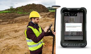
Zeno Mobile is available on Leica Geosystems new tablet Zeno Tab 2 and on most Android smartphones and tablets.
Leica Geosystems – when it has to be right
Revolutionising the world of measurement and survey for nearly 200 years, Leica Geosystems, part of Hexagon, creates complete solutions for professionals across the planet. Known for premium products and innovative solution development, professionals in a diverse mix of industries, such as aerospace and defence, safety and security, construction, and manufacturing, trust Leica Geosystems for all their geospatial needs. With precise and accurate instruments, sophisticated software, and trusted services, Leica Geosystems delivers value every day to those shaping the future of our world.
Hexagon is a global leader in sensor, software and autonomous solutions. We are putting data to work to boost efficiency, productivity, and quality across industrial, manufacturing, infrastructure, safety, and mobility applications.
Our technologies are shaping urban and production ecosystems to become increasingly connected and autonomous — ensuring a scalable, sustainable future.
Hexagon (Nasdaq Stockholm: HEXA B) has approximately 20,000 employees in 50 countries and net sales of approximately 3.8bn EUR. Learn more at hexagon.com and follow us @HexagonAB.
