(Heerbrugg, Switzerland, 9 October 2019) – Leica Geosystems, part of Hexagon, announced today a new software upgrade for Leica iCON field software as the first development under the collaboration with Procore, a leading provider of construction management software.
Leica Geosystems, Procore further collaborate to bring interoperable workflows for construction
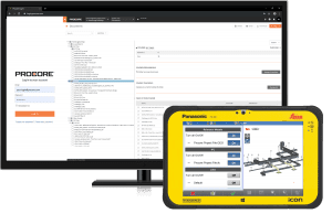
The two industry-leading providers have integrated their services for collaboration across Leica iCON field software and Procore’s suite of construction management solutions, delivering overarching functionality and efficiency to customers. Opening up the way for new project management possibilities, the collaboration establishes cloud connection between iCON field software and Procore. Users will be able to seamlessly integrate and manage data, enhancing workflows between field and office.
“We are pleased to see our best-of-breed technology partners working together to improve our experience. We believe the integration between Leica iCON and Procore will increase productivity, accuracy and efficiency for our project team members,” said David Pratt, manager of BIM/VDC services at Robins & Morton.
Empowering the construction industry with digital solutions
By leveraging the data interoperability of iCON field software with various industry standard formats and the connectivity to Procore, field crews can now connect to cloud storage directly on-site, gaining access to previously inaccessible files. This integration will enable project managers to access and communicate the most up-to-date information and make quick decisions based on true field data.
“Construction professionals work with many different technologies, systems and tools that don’t directly communicate with one another,” said Bernd Moeller, Leica Geosystems business director for field software solutions. “For any subsequent construction step the reliability and availability of the latest digital design data on site is crucial. Having the possibility to track progress with millimetre accuracy of as-built information enables these professionals to make decisions based on reliable field data.”
Leica Geosystems – when it has to be right
Revolutionising the world of measurement and survey for 200 years, Leica Geosystems, part of Hexagon, creates complete solutions for professionals across the planet. Known for premium products and innovative solution development, professionals in a diverse mix of industries, such as aerospace and defence, safety and security, construction, and manufacturing, trust Leica Geosystems for all their geospatial needs. With precise and accurate instruments, sophisticated software, and trusted services, Leica Geosystems delivers value every day to those shaping the future of our world.
Hexagon is a global leader in sensor, software and autonomous solutions. We are putting data to work to boost efficiency, productivity, and quality across industrial, manufacturing, infrastructure, safety, and mobility applications.
Our technologies are shaping urban and production ecosystems to become increasingly connected and autonomous — ensuring a scalable, sustainable future.
Hexagon (Nasdaq Stockholm: HEXA B) has approximately 20,000 employees in 50 countries and net sales of approximately 3.8bn EUR. Learn more at hexagon.com and follow us @HexagonAB.
