STUTTGART, Germany, Sept. 17, 2019—Trimble (NASDAQ: TRMB) introduced today two new software releases designed to further simplify and improve the workflow for indoor mobile mapping, while also improving the final map products that the Trimble® Indoor Mobile Mapping Solution (TIMMS) produces.
The announcement was made today at INTERGEO 2019, the world’s largest conference on geodesy, geoinformatics and land management.
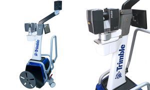
TIMMS is the optimal fusion of technologies for capturing spatial data of indoor and other difficult environments for GNSS. It provides both LiDAR and spherical video, enabling the creation of accurate, real-life representations of interior spaces and all of their contents. The maps are geo-located, meaning that the real-world positions of each area of the building and its contents are known and can be easily placed and oriented in a wide area model.
“Trimble continues to innovate for the indoor mapping surveyors with ongoing improvements and support for the TIMMS product line,” said Kevin Andrews, director of Indoor Mapping at Applanix, a Trimble Company. “Today we are releasing new, updated versions of TIMMS Spatial Processor as well as an updated version of TIMMS Control and Data Acquisition software. These new versions represent significant improvements for TIMMS users, including improved control of mission parameters with the ability to edit camera height measurements as well as pull camera calibration data directly from Trimble MX mobile mapping software. In addition, photo positions and point-cloud colorization are now more accurate, error reporting from point cloud adjustment software is enhanced, and the real-time operator workflow is improved.”
TIMMS is available through the Applanix sales channels. For more information, visit: https://info.applanix.com/e/310631/solutions-land-timms-html/dddq4z/415880961?h=joY2Nk1QzWS2LXsfIsNzQIaeued4XfzZoCl5DncuJDE or email [email protected].
About Trimble
Trimble is transforming the way the world works by delivering products and services that connect the physical and digital worlds. Core technologies in positioning, modeling, connectivity and data analytics enable customers to improve productivity, quality, safety and sustainability. From purpose built products to enterprise lifecycle solutions, Trimble software, hardware and services are transforming industries such as agriculture, construction, geospatial and transportation and logistics. For more information about Trimble (NASDAQ:TRMB), visit: www.trimble.com
