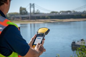
SUNNYVALE, Calif.— Trimble (NASDAQ: TRMB) announced today its Trimble® TerraFlex™ field software now supports the transfer of data between the field and office without the use of Trimble cloud services. The new software workflow—called offline data transfer—is possible through the integration of Trimble TerraFlex and the Trimble Positions™ Desktop add-in for Esri® ArcGIS® Desktop. TerraFlex is a field solution that enables mobile workers to easily collect, manage and edit their geospatial feature data. The new workflow provides an alternative to using Trimble cloud services for storing and transferring GIS feature data collected with the TerraFlex platform. In addition, TerraFlex field data collected via this workflow using a Trimble Global Navigation Satellite System (GNSS) receiver can be post-processed directly inside the Trimble Positions Desktop add-in for improved positional accuracy.
“With this new feature, TerraFlex fulfills the need of organizations such as government agencies and utility providers who cannot keep their data in the cloud because of regulatory constraints or business rules,” said Rachel Blair-Winker, business area manager for Trimble Mapping & GIS solutions. “By introducing the new workflow to our TerraFlex software platform, customers who prefer direct desktop methods of transferring data between field and office (such as USB) and need post-processing capabilities can now benefit using this new solution without having to change their current business practices.”
Availability
Trimble TerraFlex is available online at https://terraflex.trimble.com or through Trimble’s Authorized Geospatial distribution channel. The Mobile apps are available in Apple’s App Store and Google’s Play store. The Trimble Positions Desktop add-in is available through the Trimble Geospatial distribution channel. The new workflow functionality will require the latest version of both applications. For more information, visit: https://terraflex.trimble.com or https://geospatial.trimble.com/products-and-solutions/trimble-positions-desktop.
About Trimble Geospatial
Trimble Geospatial provides solutions that facilitate high-quality, productive workflows and information exchange, driving value for a global and diverse customer base of surveyors, engineering and GIS service companies, governments, utilities and transportation authorities. Trimble’s innovative technologies include integrated sensors, field applications, real-time communications and office software for processing, modeling and data analytics. Using Trimble solutions, organizations can capture the most accurate spatial data and transform it into intelligence to deliver increased productivity and improved decision-making. Whether enabling more efficient use of natural resources or enhancing the performance and lifecycle of civil infrastructure, timely and reliable geospatial information is at the core of Trimble’s solutions to transform the way work is done. For more information, visit: geospatial.trimble.com.
About Trimble
Trimble is transforming the way the world works by delivering products and services that connect the physical and digital worlds. Core technologies in positioning, modeling, connectivity and data analytics enable customers to improve productivity, quality, safety and sustainability. From purpose built products to enterprise lifecycle solutions, Trimble software, hardware and services are transforming industries such as agriculture, construction, geospatial and transportation and logistics. For more information about Trimble (NASDAQ:TRMB), visit: www.trimble.com.
