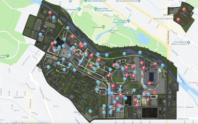
DENVER – Concept3D, a leader in creating immersive online experiences with 3D modeling, interactive maps and virtual tour software, today announced the launch of its new night map feature.
The new night map feature is a toggle-on map overlay designed to enhance campus safety and security by making it easy to find the best, well-lit routes and critical resources like emergency phones. With Concept3D’s intuitive Content Management System (CMS), clients can easily add or update routes and resources available on their night map.

The Concept3D interactive mapping platform is used by hundreds of major universities, colleges and schools, as well as convention centers, hospitals, resorts, retirement communities, data centers, and businesses. The night map feature offers all of these clients a unique way to provide their audiences with important safety and security information for visiting and navigating the campus at night.
The University of Denver, Boise State University, and Pacific Lutheran University are the first to integrate this feature into their Concept3D-powered interactive campus maps. Boise State University is using the new Night Map feature to highlight Public Safety Dispatch Centers, Emergency Blue Light and Refugee Phones, and AED locations. Each item has a display box that further explain the exact location of the service and other additional information. Pacific Lutheran uses the Night map to display campus AEDs, emergency telephones, and its safety building.
Security and safety is a major focus for higher education institutions. Colleges and universities that participate in federal Title IV student financial assistance programs must comply with the Clery Act which requires annual security reporting, details and geographic information about crimes committed on campus and on public areas immediately adjacent to the campus, and timely warnings and emergency notifications, among other requirements.
“Every client we work with wants to make their campus more welcoming, and the new Night Map feature is a unique and powerful tool that adds to the value of the Concept3D platform,” said Gordon Boyes, CEO, Concept3D. “For higher education, this new overlay can help students, staff, and visitors find the resources they need to feel more comfortable on campus at night, and the Night Map will also be a great addition for businesses, convention centers, healthcare and other campuses; helping campuses in their commitment to safety.”
The new Night Map feature is now available as an add-on upgrade for all existing Concept3D clients, and can be built into new maps.
View images and read more about Concept3D’s night map feature at: https://blog.concept3d.com/concept3ds-new-night-map-feature-supports-campus-safety-and-security?hs_preview=juhgsxvv-11875324412
About Concept3D:
Founded in 2006, Concept3D is a leader in creating immersive online experiences with 3D modeling, interactive maps and VR enabled virtual tour software. Concept3D software brings any physical location into an intuitive and navigable digital format, providing clients with a powerful competitive edge through applications like data visualization, wayfinding, virtual reality, and real time data feed integration. Concept3D clients include convention centers and event spaces, data centers, healthcare and retirement facilities, large commercial sites, resorts, hotels and theme parks, and universities and colleges, among many other locations. Learn more at https://www.concept3D.com.