(HEERBRUGG, SWITZERLAND/LAS VEGAS) – Leica Geosystems, part of Hexagon, is showcasing the Leica BLK2GO handheld imaging laser scanner, a first-of-its-kind mobile scanner, that was announced yesterday at HxGN LIVE. The BLK2GO is designed to scan complex spaces with unprecedented efficiency and speed thanks to LiDAR, SLAM (simultaneous localisation and mapping) and edge computing technologies, which enables surveyors, professionals and users to expand their reality capture capabilities.
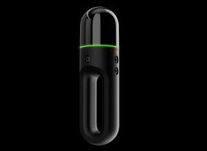
The new Leica BLK2GO handheld imaging laser scanner offers unprecedented efficiency to surveyors.
The BLK2GO is a wireless handheld imaging laser scanner that seamlessly captures 3D environments while the user is in motion, and continuously creates a digital representation of reality in the form of 3D point clouds. The BLK2GO’s compact and handheld design allows a much greater degree of mobility, as well as access to spaces and objects that may have been difficult or impossible to scan before. With simple, one-button operation and a lightweight design, it is easy to use for professional and casual users alike.
“The BLK2GO is the next step in the BLK series to democratise technology and create reality capture tools that are intuitive and accessible to users in many industries,” said Burkhard Boeckem, CTO Hexagon’s Geosystems division. “The BLK2GO is a major leap in technology and advances the powerful yet simple design of the BLK360 and offers much more speed, efficiency and mobility for users.”
Scanning in motion
With the BLK2GO, surveying teams now have the option to use a hand-held mobile scanner in addition to the solutions they use today. Combining two-axis LiDAR with visual SLAM technologies, the BLK2GO has spatial awareness to know where it is and where it has been in space and will accurately follow a user’s trajectory while scanning. When used with the iOS app, users can get live feedback while scanning, check the device status, or do quick data inspection.
“When we considered the current limitations of reality capture methods, we found an opportunity to deliver a new tool that would allow drastically new reality capture workflows to augment existing methods and tools,” said Juergen Mayer, president of the Reality Capture Division at Leica Geosystems. “There is simply no other reality capture device on the market that has the mobility of the BLK2GO, nor the ability to capture seamlessly while in motion. We anticipate that professionals and users worldwide will find innovative and exciting new applications in their reality capture projects with the BLK2GO.”
The BLK2GO is expected to be available in October 2019. For more information, please visit BLK2GO.com
Leica Geosystems – when it has to be right
Revolutionising the world of measurement and survey for nearly 200 years, Leica Geosystems, part of Hexagon, creates complete solutions for professionals across the planet. Known for premium products and innovative solution development, professionals in a diverse mix of industries, such as aerospace and defence, safety and security, construction, and manufacturing, trust Leica Geosystems for all their geospatial needs. With precise and accurate instruments, sophisticated software, and trusted services, Leica Geosystems delivers value every day to those shaping the future of our world.
Hexagon is a global leader in sensor, software and autonomous solutions. We are putting data to work to boost efficiency, productivity, and quality across industrial, manufacturing, infrastructure, safety, and mobility applications.
Our technologies are shaping urban and production ecosystems to become increasingly connected and autonomous — ensuring a scalable, sustainable future.
Hexagon (Nasdaq Stockholm: HEXA B) has approximately 20,000 employees in 50 countries and net sales of approximately 3.8bn EUR. Learn more at hexagon.com and follow us @HexagonAB.
