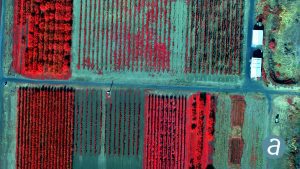
Montreal, Canada, June 4th, 2019 – SimActive Inc., a world-leading developer of photogrammetry software, announces the release of Correlator3D™ version 8.2 with advanced processing capabilities of multispectral imagery. Supported sensors include the MicaSense RedEdge / Altum and the Parrot Sequoia.
The new version allows to register multispectral as well as infrared images automatically. The resulting fused data can be used in the software to produce DSMs, DTMs and generate multiband orthomosaics with perfect co-registration.
“There is a growing need for multispectral sensors in agricultural applications such as crop management”, said Louis Simard, CTO at SimActive. “The new version allows our users to profit from the multiple bands available, seamlessly.”
About SimActive
SimActive is the developer of Correlator3D™ software, a patented end-to-end photogrammetry solution for the generation of high-quality geospatial data from satellite and aerial imagery, including UAVs. Correlator3D™ performs aerial triangulation (AT) and produces dense digital surface models (DSM), digital terrain models (DTM), point clouds, orthomosaics, 3D models and vectorized 3D features. Powered by GPU technology and multi-core CPUs, Correlator3D™ ensures matchless processing speed to support rapid production of large datasets. SimActive has been selling Correlator3D™ to leading mapping firms and government organizations around the world, offering cutting-edge photogrammetry software backed by exceptional customer support. For more information, visit www.simactive.com.
