
Asian Surveying & Mapping
Breaking News
H3 launches navigation satellite
WASHINGTON — A Japanese H3 rocket successfully launched a...
Chinese rocket carrying satellite explodes seconds after launch
Hong Kong —  A Chinese rocket set to launch a satellite...
NASA invites ISRO to join its ambitious Moon Base programme
India and the United States are set to strengthen...
India counters China’s map war: Names of 27 Arunachal Pradesh locations standardised on Survey of India maps
The official list covers 21 land locations, four mountain...
OMEGA and MBRSC launch exhibition celebrating UAE’s space milestones and Moon landing anniversary
OMEGA has partnered with the Mohammed Bin Rashid Space...
SpaceX crash site on moon revealed by South Korean orbiter
An out-of-control SpaceX rocket that crashed into the moon...
ispace Receives Grant for Japan’s Space Strategy Fund Project “High-Precision Landing Technology in the Lunar Poles Region”
TOKYO—August 7, 2026—ispace, inc. (ispace) (TOKYO: 9348), a global...
Embry‑Riddle Asia Launches Professional Space Operations Course in Singapore Amid Regional Space Boom
As Singapore works to develop its involvement in the...
ISRO to map landslides in J&K using satellite to generate alerts
According to the government, geospatial technologies are being used...
Korea to Build 3D ‘New National Map’ Under Spatial Data Strategy
The Korean government will shift its spatial information system,...

December 8th, 2025
Looq AI Expands Global Partner Ecosystem to Advance Ground-Based Reality Capture in Surveying, Engineering, and Utilities

Partnerships Across North America, Europe, and Asia Extend Survey-Grade Reality Capture and Digital Twin Solutions for Infrastructure Professionals

San Diego, CA — Looq AI, an innovator in ground-based reality capture for surveying, engineering, and utilities, today announced the expansion of its global partner ecosystem with seven new partnerships across North America, Europe, and Asia. These collaborations bring Looq AI’s fast, easy-to-use, survey-grade capture technology to new markets worldwide.
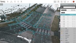
The Looq Platform’s virtual surveying provides a unified, end-to-end workflow, enabling users to efficiently draft, code, and control 3D features while easily exporting clean linework. Image courtesy of Looq AI.

The expanded network is transforming how professionals digitize and monitor critical infrastructure. It addresses the growing demand for fast, accurate, and intelligent field data capture in environments where aerial methods are limited. By complementing LiDAR and filling coverage gaps, Looq AI enables faster, safer, and more comprehensive field data collection.

The Looq Platform combines innovative hardware with intelligent software, working alongside LiDAR—or, where appropriate, replacing traditional multi-tool workflows—to give surveyors, engineers, and utilities a faster, more precise way to map and model infrastructure assets.

“Our mission is to empower professionals with tools that deliver uncompromising accuracy and measurable efficiency gains, often realized in just days, helping engineering firms reduce project costs and increase margins,” said Dominique Meyer, CEO of Looq AI.

Regional Partner Ecosystem

United States

  • AllTerra Central – Serving Texas, Oklahoma, Arizona, and New Mexico, AllTerra adds Looq AI’s survey-grade reality capture solutions to accelerate field-to-office workflows for infrastructure and utility projects. allterracentral.com
  • LiDAholics – Seattle-based provider of advanced scanning technologies that complement Looq AI’s ground-based capture, empowering professionals to deliver more accurate and complete datasets. lidaholics.com
  • Monsen Engineering – Serving Utah and Nevada, Monsen Engineering enhances its surveying and mapping portfolio with Looq AI, enabling faster and more confident project delivery. monsenengineering.com
  • Terrain LLC – Expanding Looq AI’s reach in the Northeast U.S., Terrain brings expertise in surveying, engineering, and infrastructure digitization projects, supporting utility operators and engineering firms.

Europe

  • ECOGIS Sp. z o.o. (Poland, Croatia) – Founded in 1992, ECOGIS specializes in GIS projects, digital photogrammetry, geodesy, digital mapping, and software development. These services strengthen Looq AI’s presence across Central and Eastern Europe. ecogis.pl
  • Geometius (Netherlands, Belgium, and Luxembourg) – With over 30 years of measurement expertise, Geometius integrates Looq AI’s reality capture into its comprehensive technology stack, providing European professionals with a complete digital workflow. geometius.nl

India & Middle East

  • IRIS STAR Technologies – Expanding into India and the Gulf Cooperation Council (GCC) region, IRIS STAR Technologies’ collaborations extend Looq AI’s applications across infrastructure monitoring, digital twin solutions, and geospatial surveying. www.irisstar.tech

About Looq AI:
Looq AI is a high-growth technology platform company dedicated to advancing critical infrastructure digitization and diagnosis. The company has developed a fundamental new camera technology that makes survey-grade 3D capture cost-effective at scale. The Looq Platform is a handheld, ground-based capture system—offering creation, visualization, analysis, collaboration, and integration capabilities to digitize the built world. Users work more efficiently and get accurate results for topographic mapping and modeling of transmission and distribution assets. Learn more at looq.ai.

For more information on our products and authorized resellers, visit Looq AI’s Partner’s page at https://looq.ai/partners/