
Asian Surveying & Mapping
Breaking News
H3 launches navigation satellite
WASHINGTON — A Japanese H3 rocket successfully launched a...
Chinese rocket carrying satellite explodes seconds after launch
Hong Kong —  A Chinese rocket set to launch a satellite...
NASA invites ISRO to join its ambitious Moon Base programme
India and the United States are set to strengthen...
India counters China’s map war: Names of 27 Arunachal Pradesh locations standardised on Survey of India maps
The official list covers 21 land locations, four mountain...
OMEGA and MBRSC launch exhibition celebrating UAE’s space milestones and Moon landing anniversary
OMEGA has partnered with the Mohammed Bin Rashid Space...
SpaceX crash site on moon revealed by South Korean orbiter
An out-of-control SpaceX rocket that crashed into the moon...
ispace Receives Grant for Japan’s Space Strategy Fund Project “High-Precision Landing Technology in the Lunar Poles Region”
TOKYO—August 7, 2026—ispace, inc. (ispace) (TOKYO: 9348), a global...
Embry‑Riddle Asia Launches Professional Space Operations Course in Singapore Amid Regional Space Boom
As Singapore works to develop its involvement in the...
ISRO to map landslides in J&K using satellite to generate alerts
According to the government, geospatial technologies are being used...
Korea to Build 3D ‘New National Map’ Under Spatial Data Strategy
The Korean government will shift its spatial information system,...

October 30th, 2023
Photorealistic 3D Tiles from Google Maps Platform Now Included in Cesium ion

PHILADELPHIA – Cesium is excited to announce that Photorealistic 3D Tiles from Google Maps Platform are now included with Cesium ion, the SaaS platform for tiling, combining, and streaming global-scale 3D data.

As of today’s General Availability release, these detailed, visually stunning cities are now production ready for use in your immersive 3D geospatial applications and experiences.
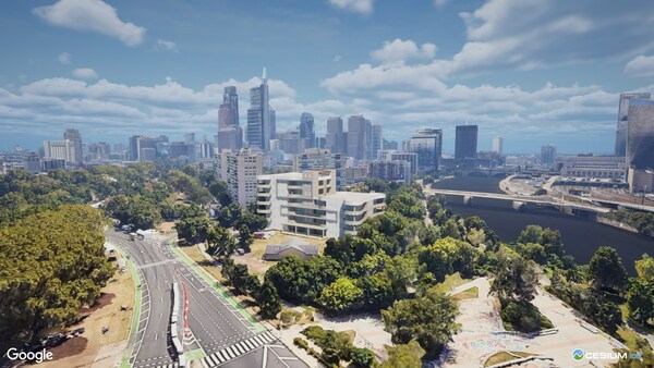
Sign up for a free Cesium ion account or simply log in to your existing account to start streaming to the web or your preferred creation engine, including CesiumJS, Unreal Engine, Unity, or NVIDIA Omniverse.

About Photorealistic 3D Tiles with Cesium ion:

  • Photorealistic 3D Tiles uses the Open Geospatial Consortium’s 3D Tiles standard created by Cesium.
  • Use Cesium ion to combine your own 3D geospatial data with Photorealistic 3D Tiles to build immersive metaverse experiences.

  • Photorealistic 3D Tiles are available in over 2,500 cities and 49 countries.

  • Cesium ion with Photorealistic 3D Tiles gives developers access to an open ecosystem of 3D Tiles-enabled runtime software, including CesiumJS, Unreal Engine, Unity, and NVIDIA Omniverse.

Since the experimental release in May, users have leveraged Cesium and Photorealistic 3D Tiles to build immersive experiences for industries such as AEC, flight simulation, real estate, and more.

Visit Cesium for more information and tutorials on building with Google’s Photorealistic 3D Tiles with CesiumJS, Cesium for Unreal, Cesium for Unity, and Cesium for Omniverse.

About Cesium – 3D Geospatial for the Metaverse
Cesium is the open 3D geospatial platform for the metaverse. Cesium created 3D Tiles, the open standard for streaming massive 3D geospatial data. With open source offerings like Cesium for Unreal, Cesium for Unity, and Cesium for Omniverse, we’re empowering creators to build digitized worlds with real-world data at scale.