Eleven Ocean Innovators Chosen Worldwide
AUSTIN, Texas – Terradepth, a leading provider of ocean data solutions, has been selected to participate in the World Economic Forum’s (WEF) prestigious Ocean Data Challenge, a program aimed at enhancing sustainable ocean management and building the blue economy. One of only 11 Challenge winners, Terradepth will become part of the WEF UpLink Innovation Network, including a mentoring program and partnering opportunities.
WEF announced the Ocean Data Challenge winners at its 2023 Annual Meeting in Davos, Switzerland. The Challenge was created by WEF in response to the United Nations’ proclamation that 2021–2030 be a Decade of Ocean Science for Sustainable Development and has called for creation of a global ocean data ecosystem to connect businesses, organizations, and government data providers.
“Terradepth is proud to be recognized by the World Economic Forum as an innovator in creating technologies that play critical roles in deepening our understanding of ocean environments,” said Joe Wolfel, CEO of Terradepth. “We look forward to working alongside some of the most influential players in the ocean science community.”
The Ocean Data Challenge selected Terradepth for its innovation in scaling ocean data collection and ocean data dissemination. Terradepth is accomplishing this by developing long endurance autonomous underwater vehicles (AUVs) that revolutionize the economics of ocean data collection and reduce its environmental impact. Additionally, as an ocean data-as-a-service (ODaaS) provider, Terradepth has spearheaded efforts to deploy low-logistics AUVs configured with multiple sensors to conduct seafloor hydrographic and geophysical surveys for a fraction of the cost of traditional surveys.
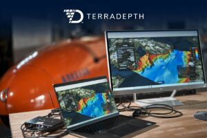
Terradepth has also developed an ocean data management solution, known as Absolute Ocean (AO). AO offers greater operational efficiencies for ocean data accessibility and is a secure, easy-to-use, cloud-native geospatial solution. AO provides high-level visualization, analysis, collaboration, and management of ocean data for both internal and external project stakeholders. Available as software-as-a-service (SaaS), AO is being used for projects ranging from environmental monitoring and engineering design to offshore energy and telecommunications infrastructure inspection.
“A vital resource for initiatives like the Ocean Data Challenge, the fully integrated AO solution provides unique insight into the ocean and seafloor for stakeholders that in the past only had access to static images, as well as the ability to manage and archive ocean data in one place for enterprise-wide access and global collaboration,” said Wolfel.
As an Ocean Data Challenge participant, Terradepth will team with other winners to focus on furthering ocean knowledge to:
The Challenge is managed by the WEF UpLink and Friends of Ocean Action initiatives. UpLink is an open platform created to connect change-makers and entrepreneurs with the goal of forging new approaches to the world’s most pressing challenges. Friends of Ocean Action is a coalition of over 70 ocean leaders who are fast-tracking solutions to issues facing ocean ecosystems.
For more information on the Ocean Data Challenge, to request a demonstration of Absolute Ocean, or to learn more about Terradepth AUV activities, go to terradepth.com, or visit booth C15 at Oceanology International Americas being held February 14–16 in San Diego, California.
About Terradepth
Terradepth is an ocean data-as-a-service company focused on scaling ocean data collection and dissemination, enabling unprecedented exploration of the underwater environment. This is accomplished by environmentally friendly survey and monitoring operations that collect ocean data at the edge, combined with an immersive, cloud-native geospatial data management solution for ocean data visualization, collaboration and analysis. These capabilities enable better and faster ocean decisions. www.terradepth.com
