Asian Surveying & Mapping
Breaking News
Nuri rocket successfully completes KAIST’s next-gen satellite mission
The Korea Advanced Institute of Science and Technology (KAIST)...
President Lai reviews progress on first indigenous satellite constellation
President Lai Ching-te said developing space technology is a...
Japan’s iQPS lines up eight SAR launches
ST. LOUIS — Japan’s Institute for Q-shu Pioneers of...
UAE Astronauts Promote AI and Collaboration in Space at GITEX Europe
The Arab world’s first astronaut, Hazzaa Al Mansouri, and...
New species of space-adapted bacteria discovered on China’s Tiangong space station
Scientists have discovered a previously unknown strain of microbe...
Isro’s 101st mission fails as PSLV-C61 suffers third-stage anomaly
India’s latest Earth observation satellite mission faced a setback...
Iraq’s First Fully Solar-Powered Village in Kulak Is Now Operational
ERBIL, Kurdistan Region – May 20, 2025 — The...
Australia’s Gilmour Space Technologies ready to launch maiden Eris Test flight the nation’s first orbital launch in over 50 years
Gilmour Space Technologies is the leading launch services company...
Korea’s space agency seeks revision of plan to modify next-gen rockets into reusable system
South Korea's aerospace agency said on Thursday that it...
UAE Space Agency Signs Agreement With Technology Innovation Institute to Execute the Emirates Mission to the Asteroid Belt’s Lander Project
In the presence of His Highness Sheikh Hamdan bin...

Author Archive

Thursday, May 4th, 2017

Pix4Dmapper 3.2 Now Generates Tiled Level-of-Detail (LoD) Mesh

Today, we are happy to announce our Pix4Dmapper Desktop 3.2 release. The new version has great advancement in stability and usability - Upload desktop projects to cloud is now 10x faster; Camera parameter correlations are displayed in...

Thursday, May 4th, 2017

Iridium Announces Successful Completion of First-Launch Iridium NEXT Satellites Activities and Second Launch Date

MCLEAN, Va. - Iridium Communications Inc. (NASDAQ:IRDM), the only communications company with 100 percent global coverage, has announced that the first set of Iridium NEXT satellites have been integrated into the operational constellation and are providing excellent...

Thursday, May 4th, 2017

Leica Geosystems’ New Miniaturized 3D Imaging Laser Scanner Simplifies the Collection of As-Built Reality Capture Data for Architecture, Engineering, Construction, and Design

Norcross, Georgia – Leica Geosystems, a leader in the world of measurement and survey for nearly 200 years, has redefined what’s possible in the imaging laser scanner market with the introduction of the BLK360, the world’s smallest...

Thursday, May 4th, 2017

Aerojet Rocketdyne’s Julie Van Kleeck Recognized as American Institute of Aeronautics and Astronautics Fellow

SACRAMENTO, Calif. - Julie Van Kleeck, vice president of Advanced Space and Launch Programs and Strategy at Aerojet Rocketdyne, a subsidiary of Aerojet Rocketdyne Holdings, Inc. (NYSE:AJRD), has been named an American Institute of Aeronautics and Astronautics...
Tuesday, May 2nd, 2017

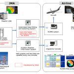
New Wind Information System Debuts at Japanese Airports

In April 2017, the Airport Low-level Wind Information (ALWIN) system, jointly developed by the Japan Meteorological Agency (JMA) and the Japan Aerospace Exploration Agency (JAXA), started operations at Tokyo International Airport (Haneda) and Narita International Airport. ALWIN...

Monday, May 1st, 2017

Sheikh Mohammed Issues Law on Surveying in Dubai

His Highness Sheikh Mohammed bin Rashid Al Maktoum, Vice-President and Prime Minister of the UAE and Ruler of Dubai, has issued Law No.06 of 2017 pertaining to surveying activity in Dubai. Read More at Khaleej Times

Monday, May 1st, 2017

China Adopts Revised Surveying and Mapping Law

China's top legislature Thursday passed a revised surveying and mapping law, protecting geographic information security and raising public awareness of national territory. Read More at CCTV

Monday, May 1st, 2017

India to Build Earth Observation Satellite for Armenia, Build Human Capacity

India is to build an Earth observation satellite for Armenia, as well as train Armenian scientists in the use of the system and handling and interpreting its data, according to Indian press reports. Read More at Space...

Monday, May 1st, 2017

ISRO Inaugurates Advanced GNSS Research Lab

The Indian Space Research Organisation (ISRO) has launched the Advanced GNSS Research Laboratory (AGRL) in the Department of Electronics and Communication Engineering at the Osmania University College of Engineering in Hyderabad, reports The Hindu. Read More at...

Monday, May 1st, 2017

Remote Sensing Data Shows Massive Diversion of Forest Land in Munnar

Thousands of hectares of forest land in Munnar, one of the world’s greatest biodiversity hotspots, have disappeared, remote sensing data shows. Read More at Mint