
Tuesday, April 28th, 2020
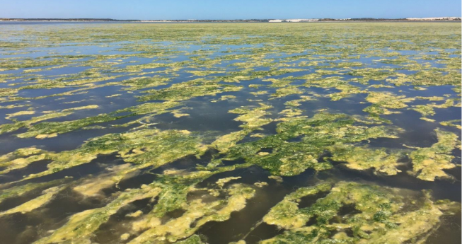
The satellite tracking is helping researchers map floating algae as it suffocates vital food plants in one of Australia’s most important bird habitats. Filamentous algae are decimating aquatic plants in the southern Coorong as it blocks seeding...
Tuesday, April 28th, 2020
(Pisa, Italy, 28 April 2020) – IDS GeoRadar, a Hexagon company, announced today Stream UP, the latest Ground Penetrating Radar (GPR) offering in its Stream product line. The new GPR is multi-channel, multi-frequency, double-polarized and lightweight. The...
Tuesday, April 28th, 2020
ROME, New York, 28 April 2020 – PAR Government Systems Corporation (PAR Government), a provider of geospatial and decision support solutions to the U.S. government for 50 years, has introduced TeamConnect TM by PAR, a commercial cloud-based...
Tuesday, April 28th, 2020
WATERLOO, Ontario, April 28, 2020 - Descartes Systems Group (Nasdaq: DSGX) (TSX:DSG), the global leader in uniting logistics-intensive businesses in commerce, announced that White Plains, NY-based Capital Logistics, a full service logistics provider with extensive expertise in...
Tuesday, April 28th, 2020
Westminster, Colo. – April 28, 2020 – Maxar Technologies (NYSE:MAXR) (TSX:MAXR), a trusted partner and innovator in Earth Intelligence and Space Infrastructure, today announced that it signed $20 million in contracts with the U.S. National Geospatial-Intelligence Agency...
Tuesday, April 28th, 2020
An Australian space innovation program with the backing of Amazon and Deloitte will be expanded to the United Kingdom this year. The inaugural Gravity Challenge was held in Adelaide last September attracting 115 innovators across 42 teams....
Tuesday, April 28th, 2020
New York, April 28, 2020 — The winners of Fast Company’s 2020 World Changing Ideas Awards were announced today, honoring the businesses, policies, projects, and concepts that are actively engaged and deeply committed to flattening the curve...
Tuesday, April 28th, 2020
Montreal, Canada, April 28th, 2020 – SimActive Inc., a world-leading developer of photogrammetry software, announces that his Correlator3D™ product is used to map the UNESCO World Heritage Site of Halin in Myanmar. The archaeological project involved the...
Tuesday, April 28th, 2020
LOS ANGELES AIR FORCE BASE, Calif. -- The Space and Missile Systems Center’s next Space Based Infrared System satellite (SBIRS GEO-5) reached a major milestone on its the road to launch when Thermal Vacuum (TVAC) testing began...
Tuesday, April 28th, 2020
Maidenhead, UK – California-based U.S. CAD is exploring the latest developments in laser scanning and working with Pointfuse to help shape the future of point cloud processing software following the completion of the Pointfuse authorized training program....