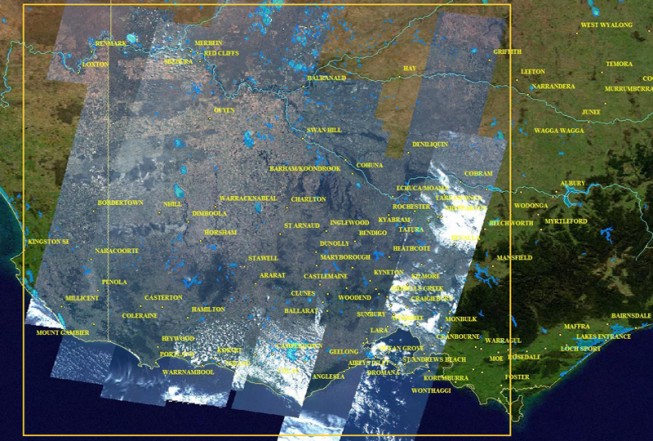
Thursday, January 27th, 2011
The RapidEye constellation of five earth observation satellites have been focused on the East Coast of Australia, dedicating resources to capture valuable images of the ever- changing face of our flooding landscape. The readily enhanced RapidEye satellite...
Saturday, January 22nd, 2011
This site hosts OCM data products (Radiance, Geo-physical Parameter , Binned ) and Scatterometer data products. Users can browse and download data products. OCM GAC data products are available from 05-JAN-2010 onwards in the form of strips...
Wednesday, January 19th, 2011
SuperGIS Server 3 is a set of map server software enabling enterprises to create, manage, and integrate various GIS services in the centralized server architecture. Therefore, types of spatial data, imagery, and GIS services can be applied...
Tuesday, January 18th, 2011
This map uses trend analysis to visualize community reports related to the flooding in Queensland. The Ushahidi social network allows anyone to report incidents via SMS, e-mail or the web. You can view all categories to understand...
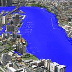
Tuesday, January 18th, 2011
AAM’s 3D Flood Simulation of Brisbane was used extensively by Australian and Global media during the recent flood crisis in Brisbane. The flood level simulations were produced interactively in 3D. This was a very effective way of communicating...
Tuesday, January 4th, 2011
PixAgri is a comprehensive service, available worldwide, that gives farming professionals more control over practices and inputs to achieve maximum profitability, by delivering field-level maps providing crop status information to help you make the right decisions. PixAgri provides...
Thursday, December 16th, 2010
On 14 December 2010 TanDEM-X mission has reached another important milestone: the test phase was completed on schedule in less than six months and prove that the operational mode, ie the collection of elevation data, can begin from...
Tuesday, December 14th, 2010
Given that we have 10 aircraft, 7 cameras, 5 LIDAR sensors and supply multiple satellite and airborne RADAR products, we can satisfy your project's imagery requirements. From archive satellite data to the latest high resolution photo maps imaged...
Sunday, December 5th, 2010
The Trimble SiteFID solution offers a completely new and innovative method to collect surface gas samples. In the past consultants and operators had to carry notebooks, maps, plans and the gas sensor to identify and mark trouble...
