As a leader in GIS data collection software for more than two decades, Trimble® has worked closely with customers to tackle the challenges of coordinate systems and geodetics. As high-accuracy GIS data becomes more prevalent, GIS professionals must enhance their understanding of these concepts to ensure data precision and reliability.
Several concepts are key to understanding the impact of coordinate systems and geodetics on GIS data collection workflows.
Datums: A datum serves as a reference point for measurements. In geodetics, the Earth’s surface is approximated by an ellipsoid, and locations are described in terms of latitude, longitude and ellipsoid height. Global datums, such as WGS84 and ITRF, are fixed to the Earth’s center and are used by GNSS systems.
However, global coordinates can change over time due to tectonic plate movements. On the other hand, local datums are usually (but not always) fixed to specific areas where tectonic motion is uniform, making them ideal for regions like Australia. We refer to datums where coordinates remain constant over time as static datums, but there are also dynamic local datums that also change over time due to tectonic activity.

Epochs: An epoch is a specific moment in time used as a measurement reference. In geodesy, epochs are crucial for dynamic datums, as they account for the time when coordinates were collected. This is important because surface features are constantly changing, and the time of measurement must be included to ensure accuracy.
Datum transformations: Datum transformations are mathematical formulas that convert coordinates between different datums. These transformations can be simple, involving shifts in X, Y and Z axes, or complex, involving additional rotation and scale parameters. Time-dependent transformations are necessary for dynamic datums, as they account for tectonic plate movements and ensure accurate coordinate conversion across different epochs.
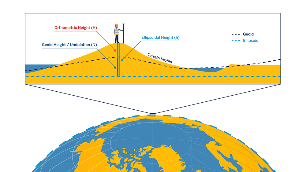
Ellipsoidal and orthometric heights: GNSS data provides heights above the WGS84 ellipsoid, not mean sea level (the most common type of orthometric height). A geoid correction must be applied to convert these (ellipsoidal) heights to orthometric heights, which are relative to mean sea level. This involves adjusting the heights based on the model of global mean sea level relative to the selected ellipsoid.
Projections: Map projections are methods used to represent the Earth’s 3D surface on a 2D plane for cartography or display. All projections distort the surface in some way, and the choice of projection depends on the properties that need to be preserved, such as area, shape or distance.
Now that we’ve covered the basics of coordinate systems and geodetic topics relevant to GIS data collection, we can start to look at common configuration problems and how they manifest themselves in your data.
But first, we need to cover one last educational topic, and it is perhaps the most important one. How do we achieve high accuracy in GNSS data collection, and what are the important geodetic considerations in that process?
The most common way of achieving high-accuracy GNSS measurements is through a process called differential correction. In this process, the difference between the measured and the true distance between a known location (a base station) and a satellite is calculated and then applied to GNSS measurements as a “correction.” Corrections can be done as soon as measurements are made (e.g., real-time) or after measurements are collected (e.g., post-processing).
Correction works generally because most error sources (e.g., atmospheric) are similar across wide areas. Differential correction can be applied to the mobile GNSS receiver measurements to eliminate most errors.
The most important aspect regarding geodetics is that the result of differential correction directly depends on the base station’s position and reference frame (combination of datum and epoch). If the base station used for differential correction is accurately defined with reference to ETRS89, then corrected GNSS measurements will also be referenced to ETRS89. This aspect applies to all forms of GNSS correction, including post-processing, RTK, VRS, etc.
It’s important to always know the correction source’s reference frame prior to starting your data collection project. This information should be available from the correction service provider in most cases. Although the specifics will vary, the most common generalization is that local correction sources like VRS and single-base RTK networks will use a local reference frame. In contrast, global correction sources like SBAS and Trimble RTX will use a global reference frame.
Surveyors or other geodetic agencies typically maintain correction service base station infrastructure. The reference position and coordinate system information are generally kept current with the latest datums and realizations. This is often in contrast to GIS systems-of-record, which utilize the same coordinate system over a longer period of time. In almost any GNSS data collection project, datum transformations will come into play at one or more points in the workflow. Properly identifying and configuring these transformations is one of the biggest sources of error and user frustration.
Let’s look at some of these configuration challenges in more detail.
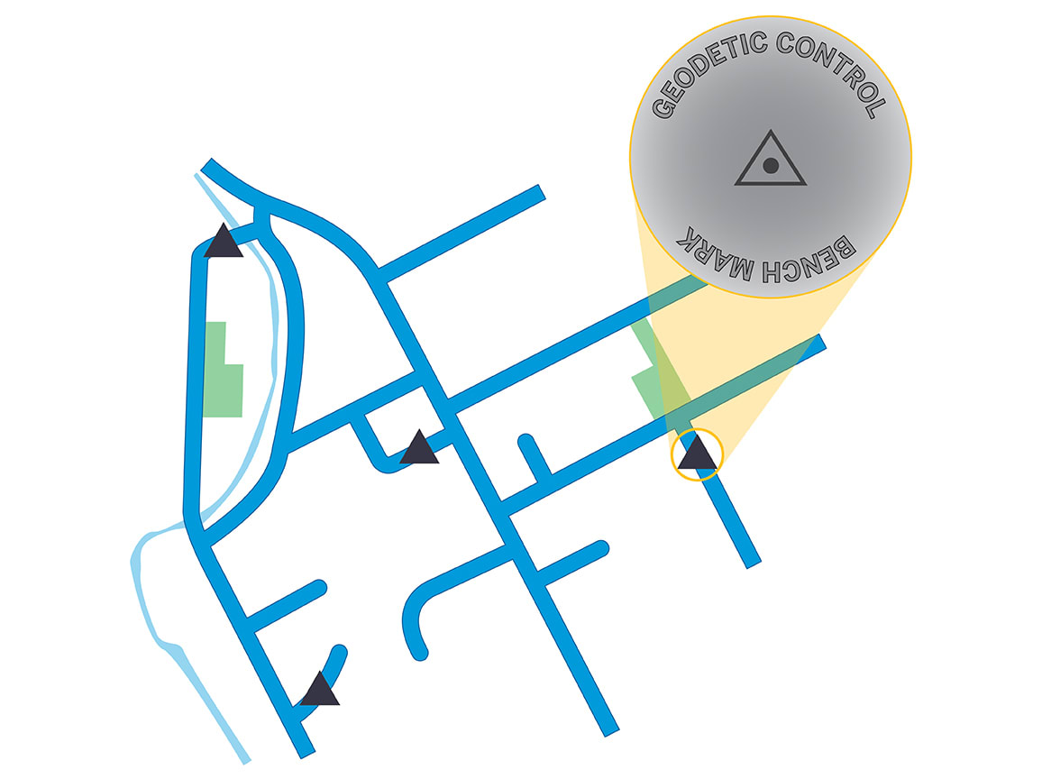
When evaluating the quality and accuracy of collected data, it’s essential to compare it against known benchmarks or control points with verified locations in an official, published reference frame. Regional or national geodetic agencies often maintain these benchmarks. If comparing against existing data, verify its accuracy by understanding its lineage, including how and when it was collected or digitized and its original coordinate system.
Historical GIS data may lack positional accuracy and might have been adjusted to look correct at certain zoom levels. Additionally, when using reference data from a local survey, known as a “site calibration,” be aware that the reference frame may be specific to the site and not match a published reference frame valid across a wider region.
Misconfigurations can lead to field-collected data appearing in incorrect locations or not showing up at all. This often occurs when the coordinate system of the field data does not match the GIS system’s expected format. For instance, the GIS might expect projected coordinates (northing, easting) while the field data uses geographic coordinates (longitude, latitude). Incorrect settings, such as the wrong zone or units, can also cause issues. In the United States, a mix of units like meters, US survey feet and international feet can complicate matters. Additionally, feature heights or coordinate Z values need careful consideration, as vertical coordinate systems and units can be set independently from horizontal ones.
Incorrect or missing datum transformations can cause significant data shifts, often resulting in offsets of several meters. This is a common challenge when integrating field-collected data into a GIS system-of-record. Datum transformations are required when working between different reference frames or coordinate systems. In a typical high-accuracy GNSS data collection workflow, multiple coordinate systems may be in-use, including the GIS source, field application, and correction sources for real-time and post-processing workflows. Proper configuration of transformations is crucial, and field validation using known control points is recommended before starting a production-level data collection project.
Even with proper configurations, limitations in datum transformations and tectonic activity can affect accuracy. Published transformations have varying accuracy based on their underlying models, and the accuracy may decrease near the boundaries of the defined area. In post-processing workflows, the choice of base station reference position can impact results, with differences ranging from 5 to 20 centimeters. In tectonically active areas, correction sources may use intermediate epochs to account for tectonic motion, which can lead to shifts in data when epochs are adjusted. Time-dependent datum transformations are essential for accurately transforming data across multiple epochs, especially in regions near plate boundaries where crustal deformation exists.
By addressing these challenges and understanding the intricacies of geodetic principles, GIS professionals can significantly improve the accuracy and reliability of their data collection workflows, ensuring that high-accuracy GIS data meets the demands of modern applications.
