Demos at APWA Show4Snow 2023 in Omaha
CENTENNIAL, Colorado – CompassCom Software has announced availability of CompassLDE Connectors for the Cityworks work order management solution that feed real-time automated vehicle location (AVL) details for viewing on the Cityworks Office and Respond maps. Updated for the latest JavaScript versions of Cityworks Desktop 3.0 and Mobile 4.0 modules, the CompassLDE Connectors also deliver valuable asset and job data to automate back-end workflows for more efficient and cost-effective operations.
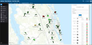
Vehicles engaged in work order activity tracked on the Cityworks dashboard using CompassCom Connector.
Built on the Esri ArcGIS JavaScript API, Cityworks provides a dynamic map interface where supervisors can assign, review, and modify work orders related to the lifecycle management of assets owned by local governments and utilities. The Cityworks platform receives routine maintenance and urgent repair requests and then assists the municipality in assigning the work order to the appropriate crew based on proximity, availability, and capabilities – tracking the job to completion.
“First introduced in 2020, the CompassLDE Connector dramatically enhanced the efficiency of Cityworks supervisors by integrating live vehicle and status information on the same map showing the locations of their work orders,” said CompassCom CEO W. Brant Howard. “The new Connector allows Cityworks users to tap into the rich data collected by the latest version of CompassLDE.”
CompassCom developed CompassLDE (Location Data Engine) as an AVL solution that was later upgraded to a mobile resource management solution for tracking any GPS-enabled device, CompassLDE is now a universal on-premises or cloud-based server capable of monitoring thousands of mobile assets in multiple fleets over all wireless communications networks.
CompassCom has enhanced the latest version of CompassLDE to gather an almost limitless array of sensor inputs, referred to as telemetry, from mobile resources in the field. Primarily related to vehicle activities, these include Ignition On/Off, Engine Diagnostics, Idle Time, Material Spreader On/Off, Plow Up/Down, Miles Traveled, and other data points. The server can even keep track of how much sand or chemical has been applied by a snowplow, for example.
“The CompassLDE Connectors push this valuable data out to the Cityworks modules for either real-time or post-event analysis,” said Howard. “The end result is better planning, management, and optimization of work orders and field operations related to public assets.”
After-event data analysis can assess crew performance, job duration, equipment condition, and materials consumption. CompassLDE data supports Cityworks in improving personnel communications, streamlining workflows, and tracking historical job details.
CompassCom will demonstrate the CompassLDE Connectors for Cityworks at the APWA Show4Snow 2023 Symposium being held April 16-19 in Omaha, Nebraska.
For more information and to schedule an online demonstration, visit the CompassCom website at www.compasscom.com or email [email protected].
About CompassCom
CompassCom has been at the forefront of the Automatic Vehicle Location industry since 1994, providing enterprise-level fleet management solutions using the Esri ArcGIS platform. Originally designed for tracking the locations and status of vehicles, the CompassTrac® app and CompassLDE® server products are now used to monitor smartphones, private mobile radios such as Motorola and any mobile assets equipped with GPS telematics. CompassCom mobile resource management solutions are used across North America by local governments, public safety agencies, public works departments, DOT and other organizations managing vehicle fleets and mobile field crews.
For more information, visit www.compasscom.com or call 1-303-680-3311.
