Enabling new opportunities in drone-based high-end aerial imaging
Copenhagen, Denmark and Oss, Netherlands – Phase One Industrial, a world-leading provider of medium- and large-format metric cameras and imaging solutions for aerial applications, has signed an agreement with Acecore Technologies, a developer and manufacturer of Unmanned Aerial Vehicles (UAVs) for cinema and creative, industrial, and security markets. Together, these companies’ high-end products are opening new opportunities in drone-based high-accuracy mapping and inspection markets.
“The integration of the Phase One iXM camera with the Acecore drone allows full control from the ground, preventing unexpected errors that would require repeated flights and therefore saves precious time,” said Koen Vrints, Professional UAV Surveyor at Koen Vrints BVBA.
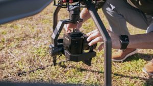
An Acecore drone integrated with Phase One camera in action
Phase One Industrial developed the iXM series – revolutionary and uniquely designed cameras for UAV-based aerial imagery that redefine the boundaries of technological innovation. The iXM 100MP and iXM 50MP are high-productivity metric cameras with a range of specially designed RSM lenses. The iXM cameras are ready for easy integration with a wide range of UAV platforms, delivering superior quality aerial imaging and flexible operation to satisfy diverse mapping, surveying, and inspection applications.
Under the new agreement, Acecore will support Phase One Industrial’s iXM range of cameras in the UAV market for high-accuracy mapping and inspection. Acecore will be using the iXM camera in three drone models: ZOE, NEO and NOA, offering fast and efficient, simple, and reliable UAV solutions. The Acecore NOA flagship model can fly up to 45 minutes with any PhaseOne iXM / iXM-RS camera and lens option.
Acecore has given operators full control over the Phase One Industrial cameras’ features during flight. All iXM / iXM-RS range cameras can be seamlessly swapped from a traditional bottom mount to a top mount configuration. The latter will prove especially useful whilst inspecting structures, such as bridges, from the bottom up.
Being weatherproof and resistant of up to 35knts wind, the European-made Acecore drone and PhaseOne iXM range cameras will enable users to experience far less downtime.
“Our cameras exemplify Acecore’s mission to optimize, increase efficiency and inspire UAV mapping and inspection missions. As an industry leader, we are confident that they will help our strategic efforts to evolve the industry through innovative solutions using Phase One Industrial technology,” said Dov Kalinski, CEO, Phase One Industrial.
Jorrit Linders, Founder and CEO, Acecore explains, “A competent payload is what gives our drones purpose and turns them into useful tools to save money, time and effort. Working together with Phase One Industrial allows us to add a powerful fully integrated camera-drone combination to our line-up, tied together by an intelligent Gremsy gimbal.”
About Acecore
Founded in 2013, Acecore Technologies is a leading developer and manufacturer of Unmanned Aerial Vehicles for cinema and creative, industrial, and security markets. Based in The Netherlands, Acecore uses only locally sourced materials and OEM components. The Neo, Zoe and Noa are proudly designed as functional, safe, and beautiful European-built UAVs.
For more information, please go to: www.acecoretechnologies.com
About Phase One Industrial
Phase One Industrial, a division of Phase One A/S, researches, develops and manufactures medium and large format digital photography systems, software and imaging solutions for industrial markets. Solutions range from aerial image acquisition to machine vision applications and cultural heritage preservation. Whether mapping the globe, executing industrial inspections or preserving priceless works of art and documents, the focus is on imaging accuracy.
Headquartered in Copenhagen, Phase One Industrial is dedicated to delivering exceptional image quality, productivity and user experience. With offices in Colorado, Cologne, Tel Aviv, Beijing and Tokyo and with its expert teams of global partners, Phase One Industrial serves and supports its customers worldwide.
To find out more about Phase One Industrial products, please visit https://industrial.phaseone.com.
