
Asian Surveying & Mapping
Breaking News
From drones to space tech, Japan looks to startups to strengthen its defences
Tokyo is stepping up efforts to harness dual-use technologies...
South Korea’s Space Agency Seeks 47% Budget Hike for 2027; Regular Nuri Launches, Lunar Lander Development to Begin
The Korea AeroSpace Administration (KASA) has proposed a 2027...
Space42 launches Future Spacers Programme to develop UAE space talent
Space42, the UAE-based AI-powered SpaceTech company, has launched the...
US, China arm for space warfare: hunter satellites and orbital weapons
Amid the rapidly-evolving field of military space operations, Beijing...
ISRO Puts India’s First Geo Imaging Satellite In Orbit, PM Modi Hails EOS-05 Launch Aboard GSLV-F17
The Indian Space Research Organisation (Isro) successfully launched EOS-05,...
China releases first nationwide geometric benchmark imagery, setting a unified ‘spatial scale’ for satellite remote sensing
China's Ministry of Natural Resources has released its first...
India to have its own space station by 2035, says ISRO chairman
Speaking at the 14th convocation ceremony of IIT-BHU, ISRO...
Isro will not make any launch vehicle, all tech to be handed to private sector
IN-SPACe chairman Pawan Goenka said Isro is moving launch...
North Korea fires ballistic missiles as US-South Korea drills near end
South Korea has condemned North Korea’s launch ⁠of more...
Orbitworks ships UAE-built Altair-1 to US ahead of October launch
Abu Dhabi-based satellite company Orbitworks has shipped Altair-1, the...

July 31st, 2020
Population Projections (2020-2100, USA) as KML, GeoJSON, Shapefile

NEWTON, MA (USA) – Maptitude U.S. County Projection Data 2020-2100 are available and includes 2,448 columns of nationwide cross-tabulated demographics by age, race, gender, and ethnicity.
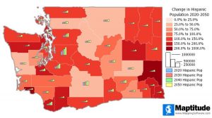
The new data allow you to target areas by growth using demographic forecasts by 5-year increments out to 2100. These detailed projections are perfect for site location, competitive analysis, marketing campaigns and any kind of analysis that involves considering future population counts. This wealth of data can be leveraged by marketers and business analysts using Maptitude mapping software, a comprehensive application for data exploration.

The County Projections data are free for Maptitude 2020 users, and are also available as shapefile, KML, KMZ, or GeoJSON for a fee. If you have any questions about Maptitude or data availability contact the Maptitude team.

About Caliper

Caliper Corporation develops state-of-the-art Geographic Information Systems (GIS) software. With a focus on usability, Maptitude is designed to be a cost-effective, professional mapping software product. Maptitude enables organizations to leverage their location-based data to improve decision making and planning, while minimizing expenditure through competitively priced solutions.

Caliper is a privately held corporation and is a leading developer of mappingredistrictingtransportation, and GIS software