BERLIN, Germany: UP42, a developer platform and marketplace for geospatial data and analytics, today announced a new partnership with Vultus, a leader in precision farming technologies. UP42 customers can now use Vultus Fertilization Zoning Maps algorithms to fine-tune crop management—with more agricultural technologies coming soon.
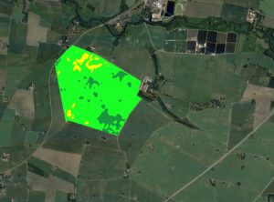
Output of the Vultus Fertilization Zoning Maps Processing Block on the UP42 Platform.
Founded in Lund, Sweden, in 2016, Vultus AB provides a geospatial infrastructure for precision farming. Vultus analyzes Earth observation satellite data with advanced Artificial Intelligence (AI) algorithms to give farmers insights into the health of crops within small sections of their fields, enabling them to apply fertilizers variably across the field.
“Growers reduce nitrogen-based fertilizer use by up to one third while increasing yield by three to five percent with the Vultus technology,” said Robert Schmitt, Vultus CEO. “This results in lower operating costs and significantly less environmental harm.”
Fertilization Zoning Maps—the first in a series of proprietary algorithms Vultus brings to UP42 as a partner—shows farmers which parts of their fields need more or less fertilizer. Conventional methods of fertilizer application treat all areas of a field uniformly, despite specific areas requiring a tailored approach. Integrating AI, historical data, and three years of extensive research, Fertilization Zoning Maps divide fields into five zones that are classified according to the variable fertilization rate the soil requires.
Understanding the diverse requirements within a field allows for improved nutrient placement and uptake, increasing production, and leading to better understanding of intra-field variability over time. In an industry with very tight profit margins, this technology gives growers a competitive edge.
CEO at UP42, Sean Wiid shared, “We’re very happy to announce a new partnership with Vultus, an emerging leader in the agritech industry. Our partnership is a key step towards providing UP42 users with a simplified way of building precision agriculture solutions. We look forward to launching new capabilities and supporting the agritech industry together.”
By partnering with Vultus, UP42 brings cutting-edge precision farming technologies to the users of its geospatial developer platform and marketplace for Earth observation data and analytics. With the addition of Vultus technologies, UP42’s agriculture customers can pick and choose combinations of data and processing algorithms for their area of interest and retrieve results on a single scalable platform.
“Farming has always been a tough business, with high costs and low margins,” added Schmitt. “This exciting partnership with UP42 means we can give growers new possibilities to use the latest research and satellite data to easily reduce their nitrogen fertilizers and increase their yields.”
About UP42
UP42 is changing the way geospatial data is accessed and analyzed. The developer platform and marketplace bring together multiple sources of data such as satellite imagery, weather data, and more—together with algorithms to identify objects, detect change, and find patterns. Industry leaders use UP42 to inform business decisions and build scalable customer solutions. Know when and where to fertilize crops. Measure air quality and map emissions. Count cars, trucks, planes, and ships. Developers and data scientists across all industries now have access to a platform to build, run, and scale projects in one place.
About Vultus
Using remotely sensed satellite data, Vultus makes variable-rate nitrogen applications easy. Our patented fertilizer prescriptions can be downloaded straight from satellite to tractor. Via cloud-penetrating technology, Vultus delivers deep insights into intra-field crop needs without expensive fieldwork or devices. With these precision tools, farmers can reduce their nitrogen fertilizer use by up to 1/3rd and increase their crop yields between 3-5%.
For more information, please contact:
Ganesh Venkatesh, Head of Marketing, UP42 [email protected]
Mikhail Seregin, Head of Marketing, Vultus [email protected] / + 46 76 075 96 58
