The firm will provide data and technology to support nautical charting, navigation, territorial limits and coastal resources across the country.
DAYTON, Ohio (July 7, 2020) — Woolpert has been selected as a prime consultant for the National Oceanic and Atmospheric Administration’s (NOAA) Shoreline Mapping Support Services contract. The firm and its partners will provide updated charting data and analytics of the national shoreline for use in nautical charts, to support maritime navigation, to define territorial limits and to manage coastal resources. The five-year indefinite delivery, indefinite quantity contract will support NOAA’s National Ocean Service (NOS), National Geodetic Survey (NGS) and Remote Sensing Division (RSD). The contract has a ceiling of $40 million.
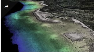
The Shoreline Mapping Support Services contract is being administered by NOAA’s NGS. Previous awards under this contract included lidar collection, aerial imagery acquisition, shoreline compilation, GRAV-D and disaster relief. Woolpert specializes in the collection and processing of high-resolution topographic and bathymetric lidar and imagery, acoustic hydrographic services and marine survey.
Woolpert also is under contract with NOAA’s Office of Coastal Management to acquire geospatial data of U.S. coastal regions and the Great Lakes, and Woolpert is part of a team contracted to provide Professional and Technical (ProTech) Services Oceans Domain support.
“We’re honored to be selected for this contract to support NOAA’s shoreline mapping program,” Woolpert Vice President and Maritime Market Director John Gerhard said. “We expect this contract to demand extensive data acquisition and processing for multiple geospatial and hydrographic needs, and we look forward to providing the information and technology that will propel the vital efforts of the NOS, NGS and RSD.”
About Woolpert
Woolpert is committed to a vision to become the premier architecture, engineering, geospatial (AEG) and strategic consulting firm, and one of the best companies in the world. It’s a vision we’ve been fine-tuning for decades. It guides our decisions and investments, provides our clients with optimal solutions and offers our employees unrivaled opportunities. Woolpert is recognized as a Great Place to Work by its employees and is America’s fastest-growing AEG firm. With more than a century of experience, close to 1,000 employees and 30 offices, Woolpert supports public, private, federal, and U.S. military clients nationally and around the globe. For more information, visit woolpert.com and connect with us on LinkedIn, Twitter, Facebook and Instagram
