MALA GPR Australia is proud to present MALÅ MIRA HDR, the new GPR array system. It’s the professional choice for large scale 3D GPR mapping and will help customers around the world to create detailed 3D maps of the subsurface with the highest resolution on the market.

MALA GPR Australia launches all new MALÅ MIRA HDR, a large area 3D GPR mapping solution with the highest data quality and resolution on the market, highway speed survey capability, improved mechanical design and new user-friendly software.
MALÅ MIRA HDR is specifically designed for large scale high-resolution 3D GPR mapping of the subsurface and enables cost effective large area mapping. It can be operated at highway speed with full resolution and delivers the highest GPR data quality on the market.
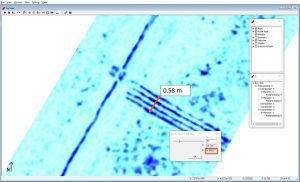
Data Image: The screen dump shows the incredible resolution of the new MIRA HDR @ 500Mhz. Four parallel utilities are clearly identified within 580mm at a depth of 0.8m. This kind of resolution is reserved for only the very best of 3D GPR systems.
There are several areas of usage where the MALÅ MIRA HDR will be highly valuable to the users, such as large-scale Utility mapping, Archaeological mapping, Road mapping and profiling.
MALA GPR Australia have been operating 2 of the original MALA MIRA 3D GPR systems for over 10 years. We have a 12 channel 400MHz and a 31 channel 1300MHz set up for large scale operations on our stable and proven John Deere acquisitioning platform. If you are interested in renting a MIRA HDR system or having us assist on a project see here for our Special Projects division.
MALA GPR Australia is proud to launch MALÅ MIRA HDR, which sets a new standard for 3D GPR mapping. Click below for more information on this new 3D GPR Solution or contact us.
