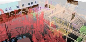
The Mississauga, Ontario office of Hatch was originally commissioned to produce detailed floor plans and undertake flow studies of a multi-level, mixed use facility comprising both hazardous industrial processes and office space. Hatch commissioned a full 3D laser scan of the facility resulting in the capture of more than 120 Gb of data. Initially civil designers at Hatch tried manipulating the raw point cloud data in order to locate walls, floors, ceilings etc., however this proved extremely labour and computer processing intensive.
“Using the raw point cloud data we were able to make a start on the floor plans,” commented John Hemingway, Senior Project Manager at Hatch. “However, despite spending in excess of 60 projects hours our rough sketch was incomplete and our systems kept crashing due to the size of the point cloud. We quickly concluded this approach was untenable.”
Using Pointfuse the original point cloud was converted into a classified mesh model in less than two project days. Having created a 3D model where individual features and surfaces could be selected and classified as distinct layers in the Pointfuse model, the envelope geometry was then converted into a parametric BIM model of the facility. This model was exported and presented to the end client as a multi-level floor plan in CAD.
Pointfuse also supported the team at Hatch helping them to further optimize the classification of the mesh model to identify and extract the location of emergency fixtures such as fire extinguishers, eye wash stations and emergency exits. Isolating the geometries of specific elements in the classified model also meant that dimensional information of specific beams and column supports could be extracted for structural studies.
“With the support of Pointfuse we were able to meet the delivery requirements and exceed the client’s expectations,” continued Hemingway, “and, having proved the power of Pointfuse on this project, we will definitely be looking for opportunities on future infrastructure planning projects.”
Contacts:
Editorial enquiries to Robert Peel, [email protected], +44 (0)1666 823306
Reader and advertising enquiries to Mark Senior, [email protected], +44 (0) 208 017 8600
Pointfuse is a powerful modeling engine that delivers an automatic, precise and flexible way of converting the vast point cloud datasets generated by laser scanners or photogrammetry into segmented mesh models. Pointfuse uses advanced statistical techniques to create 3D models where individual surfaces can be selected and classified as new layers in the Pointfuse environment and exported to IFC and FBX for manipulation in any industry-standard CAD system.
Pointfuse also significantly reduces the file size of 3D models created from point clouds. In simple terms, the data density within each surface is reduced whilst still maintaining the fidelity of the model. This results in a significant reduction in model size making ongoing use of the model easier, faster and more efficient. http://pointfuse.com
