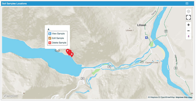
VANCOUVER, British Columbia – Flowfinity Wireless Inc. today released a software update that allows users to manage data records and workflows geographically by rendering physical locations onto maps in reporting dashboards, leveraging data visualization to improve operations.
Organizations in a variety of industries including, environmental services, engineering, construction, and field services, currently utilize Flowfinity to capture field data and streamline custom workflows for daily operations and unique projects.

Location data can now be tied directly to digital workflows and tracked in popular GIS and mapping solutions, including Esri, MapBox, and MapTiler, within Flowfinity without the need to set up external integrations.
You can now create and edit field data directly in a dashboard map display widget that ties data records to locational GPS coordinates. This empowers users to visualize and analyze field data in its geospatial context to enhance operational intelligence. Connect to multiple map tile sources and custom styles to design your ideal mapping solution.
“We’re very excited to bring mapping functionality to market, some of our most successful deployments have featured GIS mapping integrations and now those capabilities are included within the Flowfinity solution,” said Alex Puttonen, Marketing Manager, Flowfinity. “This will have an immediate benefit for existing clients and open doors for growth, particularly in the Environmental Services sector.”
When projects require data collection in difficult terrains and weather conditions, you can create and edit data for GPS coordinates that are directly inaccessible to field workers by plotting points of interest from within your dashboard map. Flowfinity also features offline capabilities for data collection in out of service areas.
For more details about the latest Flowfinity software release, visit: https://www.flowfinity.com/apps/new-features.aspx
About Flowfinity
Flowfinity is a no-code application configuration toolset used to digitize and automate custom business processes based on complex data models. Flowfinity empowers IT and business professionals to build flexible, scalable field data collection apps and workflows without committing the resources required to write and maintain code. Our intuitive platform combines a web-based app editor, cloud database, advanced mobile data collection, interactive dashboards, process automations, and reliable integrations. For more information, please visit: https://www.flowfinity.com