The main objective of Multi-GNSS Joint Experiment 2011 is to promote the utilisation of Multi-GNSS including QZSS in Asia Oceania Region by demonstrating quantitative impacts of Multi-GNSS and exploring new GNSS applications of more available satellite signals and more accurate satellite positioning service,” indicates the organisation, which has issued a Call for Applications.
This is achieved through providing better coverage within inner city environments. As might be expected, the improved coverage will result in the possibility to innovate and develop new applications.
This has important positive ramifications for those applications beyond traffic alone. It could lead to the development of security, human movement and even inner city infrastructure possibilities.
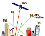
“The QZSS aims at improving positioning accuracy of one meter to the centimeter level compared to the conventional GPS error of tens of meters by transmitting support signals and through other means,” says Japan Aerospace Exploration Agency (JAXA).
Such a gain in level of accuracy is hard to imagine at the present time – for civilian use, although professional grade equipment often achieves this level of accuracy.
Without doubt the major gains will be within inner city environments, however, the QZSS satellites will provide a wider area of cover that reaches over the entire country and beyond.
This capability will ensure agrcultural, rural, fishery and other applications are similarly improved. At the present time the organisation is seeking input to new applications and the information can be found here.
CALL FOR APPLICATIONS: JAXA’s Multi-GNSS Joint Experiment 2011


