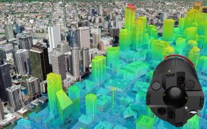
HEERBRUGG, Switzerland, 17 September 2019) – Leica Geosystems, part of Hexagon, introduces the Leica CityMapper-2. This next generation hybrid oblique imaging and LiDAR sensor provides fast and efficient digitisation of cities.
Leica CityMapper-2 hybrid airborne sensor increases productivity and data quality for creation of digital twins of cities and metropolitan areas.
As part of Leica Geosystems’ RealCity solution, which combines the CityMapper-2 with the Leica HxMap high-performance processing workflow, the new sensor is designed to provide faster updates while preserving image quality over a wide range of flying conditions.
The most significant improvement comes from the newly developed optical system incorporating two nadir (RGB & NIR) and four oblique 150 MP metric cameras using CMOS technology and equipped with Leica Geosystem’s unique mechanical forward-motion-compensation (FMC). The LiDAR sensor’s pulse repetition frequency has been increased to 2 MHz and features gateless Multiple-Pulses-in-the-Air (MPiA) technology.
“This newly developed hybrid oblique imaging and LiDAR sensor is the most advanced airborne sensor in the market for highly-productive creation of 3D digital twins,” said John Welter, Hexagon’s Geospatial Content Solutions president. “We are pleased to offer a solution that transforms the way our industry enables the digitisation of the world we live in to help manage it in the most efficient way.”
More information, smarter decisions
The new optical system uses backside illumination (BSI) CMOS technology and customised low-distortion lenses specifically designed to deliver the highest image quality and photogrammetric accuracy without reducing collection efficiency. While traditional camera systems restrict operators to high shutter speeds or decreased aircraft speed to control image blur, mechanical FMC allows the CityMapper-2 to capture high quality imagery even in difficult lighting conditions with no reduction in efficiency.
The LiDAR sensor delivers 3-centimetre range accuracy and is optimised for data capture in urban landscapes to deliver extremely accurate data and even point distribution across the data set.
CityMapper-2 is a compact package with embedded system controller and storage, which makes it easy to install in any survey aircraft. The system is available in two configurations for standard and high-altitude flights to meet customers’ needs and local flight regulations.
The sensor is supported by HxMap, the unified multi-sensor high-performance processing workflow available for all Leica Geosystems airborne sensors. The software suite has the capability to process imaging and LiDAR data in the same user interface, reducing the training requirements for staff when processing data from different sensors. Combining the new CityMapper-2 with HxMap offers the foundation to produce all airborne data products for smart decision making in rapidly changing urban environments.
To learn more about the new Leica CityMapper-2, please visit: https://leica-geosystems.com/products/airborne-systems/leica-citymapper-2/
Leica Geosystems – when it has to be right
Revolutionising the world of measurement and survey for nearly 200 years, Leica Geosystems, part of Hexagon, creates complete solutions for professionals across the planet. Known for premium products and innovative solution development, professionals in a diverse mix of industries, such as aerospace and defence, safety and security, construction, and manufacturing, trust Leica Geosystems for all their geospatial needs. With precise and accurate instruments, sophisticated software, and trusted services, Leica Geosystems delivers value every day to those shaping the future of our world.
Hexagon is a global leader in sensor, software and autonomous solutions. We are putting data to work to boost efficiency, productivity, and quality across industrial, manufacturing, infrastructure, safety, and mobility applications.
Our technologies are shaping urban and production ecosystems to become increasingly connected and autonomous — ensuring a scalable, sustainable future.
Hexagon (Nasdaq Stockholm: HEXA B) has approximately 20,000 employees in 50 countries and net sales of approximately 3.8bn EUR. Learn more at hexagon.com and follow us @HexagonAB.
Hexagon is a global leader in digital solutions that create Autonomous Connected Ecosystems (ACE). Hexagon (Nasdaq Stockholm: HEXA B) has approximately 20,000 employees in 50 countries and net sales of approximately 3.8bn EUR.
