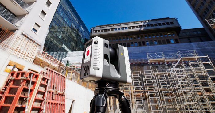
Hexagon AB, a global leader in digital solutions, today announced the launch of the Leica RTC360, a laser scanner equipped with edge computing technology to enable fast and highly accurate creation of 3D models in the field. It’s one of the many innovations on showcase this week at HxGN LIVE 2018, Hexagon’s annual digital technology conference.
The RTC360 combines high-performance laser scanning, edge computing, and mobile app technologies to pre-register captured scans quickly and accurately. With the push of a button, two million points per second of High Dynamic Range (HDR) imagery can be captured to create a full-dome scan in under two minutes. Laser scanner movements between setup positions are automatically tracked by a Visual Inertial System (VIS) while scans are combined and pre-registered on a mobile device, where they can be viewed and augmented with information tags – saving precious time and speeding up decision-making right from the field.
“We designed the Leica RTC360 for maximum productivity. For construction professionals, plant operators, public safety officials, and other professionals who face complex projects with tight constraints, it provides a better way to digitally capture the reality of their sites – and process and visualise that data for faster, immediate decision making,” said Ola Rollén, Hexagon President and CEO. “What these professionals do on site every day is challenging, and we aim to continue to make their work quicker, easier, and more accurate.”
For further information, please contact:
Maria Luthström, Investor Relations Manager, Hexagon AB, +46 8 601 26 27, [email protected]
Kristin Christensen, Chief Marketing Officer, Hexagon AB, +1 404 554 0972, [email protected]
Hexagon is a global leader in digital solutions that create Autonomous Connected Ecosystems (ACE), a state where data is connected seamlessly through the convergence of the physical world with the digital, and intelligence is built-in to all processes.
Hexagon’s industry-specific solutions leverage domain expertise in sensor technologies, software, and data orchestration to create Smart Digital Realities™ that improve productivity and quality across manufacturing, infrastructure, safety and mobility applications.
Hexagon (Nasdaq Stockholm: HEXA B) has approximately 18,000 employees in 50 countries and net sales of approximately 3.5bn EUR. Learn more at hexagon.com and follow us @HexagonAB.
