18 October, 2017, Bologna, Italy – Siteco announces the implementation of the Road-SIT Survey Software application, for the management of the maintenance and rehabilitation interventions of the utilities networks.
The most immediate and frequent need for (public) utilities, is being able to quickly assess the cost of maintenance and rehabilitation interventions, in order to plan the required investments.
Underground facility plans are usually available and rich of information such as the relative depths to the ground level, but to get a proper estimate of maintenance costs, it is essential to make a topographic survey to define the real state of the area in question.
A survey conducted with a Mobile Mapping System is generally faster, by 10 to 100 times according to the specific context, than a site inspection made with traditional tools.
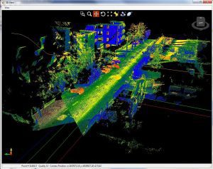
By using the Road-SIT software package, detailed information contained in the images and point clouds of the Mobile Mapping survey can be easily integrated with the data available in the existing GIS cartography. The mapped pipelines are inserted into the design with the exact depth against the ground level and positioned in transverse or longitudinal section, according to their position with respect to the section direction.

Road-SIT Survey provides smart features to process all the data and automatically generate the final project drawings (layouts, profiles and cross sections, positioning of the utilities). These are produced in AutoCAD format and can be quickly completed with quotes, labels, constructive indications, and so on.
As a final step the user can easily exploit all the data to get the necessary intervention cost assessment and estimates.
“We have received enthusiastic feedback from our customers”, says Ing. Augusto Burchi, Siteco’s Technical & Sales Director, “in terms of both productivity and reliability, and it is our intention to continue developing and enhancing the application by meeting the market demand”.
About Siteco Informatica srl – A unit of the Gavio Group, one of Italy’s top industrial groups, Siteco was established in 1995 as a civil engineering infrastructure, software and technical consulting firm. In 2005 they developed the first scalable, high performance fully integrated mobile mapping system and have since then been delivering the most flexible roadway management mobile mappers in terms of price, performance and software usability. Siteco’s Road Scanner hardware and software products are fully compatible with Faro, Z+F, Leica, Riegl, Teledyne Optech, Topcon, Teledyne and other mobile mapping systems and sensors.
