Asian Surveying & Mapping
Breaking News
Ecolab and ITE partners to harness water management knowledge for Singapore data center engineers
SINGAPORE, 29 APRIL 2024 – Nalco Water, an Ecolab...
NASA releases satellite photos of Dubai and Abu Dhabi before and after record flooding
NASA released photos of parts of Dubai and Abu...
Singapore releases 10-year Geospatial Master Plan
Singapore has launched its new Geospatial Master Plan (2024–33),...
Japan announces plans to launch upgraded observation satellites on new flagship rocket’s 3rd flight
TOKYO (AP) — Japan’s space agency announced Friday a...
Tesla China partners with Baidu for maps to clear FSD hurdle
Amidst Elon Musk’s unannounced trip to Beijing, China this...
ESA opens ideas factory to boost space innovation in Austria
A centre to innovate the design and manufacture of...
Japan’s space agency sets June 30 as third launch date for H3 rocket
The Japan Aerospace Exploration Agency (JAXA) announced Friday that...
S. Korea launches nanosatellite for Earth observation
SEOUL- A South Korean nanosatellite was launched into orbit...
Australian Space Agency funds development of aerospace-grade GNSS receiver
The Australian Space Agency has funded the development of...
Continuity risks for Australian EO data access
A new report details the widespread use of Earth...

August 16th, 2016
China Launches Gaofen-3

image
A Long March 4C rocket carrying Gaofen-3 lifts off from China's Taiyuan Satellite Launch Center. (Credit: Xinhua/Zhang Hongwei)

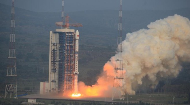
A Long March 4C rocket carrying Gaofen-3 lifts off from China’s Taiyuan Satellite Launch Center. (Credit: Xinhua/Zhang Hongwei)

On Aug. 9, 2016, China launched its Gaofen-3 remote-sensing satellite aboard a Long March-4C rocket. Designed by the China Academy of Space Technology, Gaofen-3 features a multi-polarized C-band synthetic-aperture radar (SAR) sensor at meter-level resolution.

The new satellite has a designed lifespan of eight years and will mainly be used by the State Oceanic Administration of China. As China’s first SAR imaging satellite accurate to one meter, Gaofen-3 will be used for disaster warning, weather forecasting, water-resource assessments and the protection of maritime rights.