Asian Surveying & Mapping
Breaking News
Nuri rocket successfully completes KAIST’s next-gen satellite mission
The Korea Advanced Institute of Science and Technology (KAIST)...
President Lai reviews progress on first indigenous satellite constellation
President Lai Ching-te said developing space technology is a...
Japan’s iQPS lines up eight SAR launches
ST. LOUIS — Japan’s Institute for Q-shu Pioneers of...
UAE Astronauts Promote AI and Collaboration in Space at GITEX Europe
The Arab world’s first astronaut, Hazzaa Al Mansouri, and...
New species of space-adapted bacteria discovered on China’s Tiangong space station
Scientists have discovered a previously unknown strain of microbe...
Isro’s 101st mission fails as PSLV-C61 suffers third-stage anomaly
India’s latest Earth observation satellite mission faced a setback...
Iraq’s First Fully Solar-Powered Village in Kulak Is Now Operational
ERBIL, Kurdistan Region – May 20, 2025 — The...
Australia’s Gilmour Space Technologies ready to launch maiden Eris Test flight the nation’s first orbital launch in over 50 years
Gilmour Space Technologies is the leading launch services company...
Korea’s space agency seeks revision of plan to modify next-gen rockets into reusable system
South Korea's aerospace agency said on Thursday that it...
UAE Space Agency Signs Agreement With Technology Innovation Institute to Execute the Emirates Mission to the Asteroid Belt’s Lander Project
In the presence of His Highness Sheikh Hamdan bin...

satellite image

Tuesday, September 20th, 2016

TerraColor Australia and New Zealand Landsat 8 Mosaics Released

Earthstar Geographics LLC (San Diego, CA, USA) announced the release of their new TerraColor NextGen 15-meter resolution Landsat 8 satellite image mosaics covering Australia and New Zealand.   The products are seamless mosaics of pan-sharpened true color...

Monday, May 23rd, 2011

Drought Shrinks China’s Largest Lake to Historic Low

Stricken by a severe drought, Poyang Lake, the largest freshwater lake in China, recently began to shrink severely. According to the latest reports from satellite remote sensing, the current water area of Poyang Lake is 1,326 square...

Friday, May 20th, 2011

Satellite Image Reveals Spread of a Megacity

A newly released satellite image reveals Istanbul, the largest city in Turkey at 15 million inhabitants, is quickly becoming a "megacity" covering almost 700 square miles. A newly released satellite image reveals Istanbul, the largest city in Turkey...

Wednesday, May 4th, 2011

Fires in Amur Region: Data from Space

Over 100 "hot spots" - probable fire blazes - have been detected on May 3 in Amur Region according to operational satellite-based monitoring data. Thermal anomalies are detected using MODIS sensors of Terra and Aqua satellites. Fire...

Thursday, March 31st, 2011

Why Do Russian Images of Earth Look So Different from NASA’s?

It was taken by a Russian spacecraft, a new weather satellite called Elektro-L. It’s now orbiting Earth on a geostationary orbit 36,000km above the equator, after being launched on January 20 from the Baikonur Cosmodrome, on board...
Thursday, March 24th, 2011

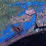
TerraSAR-X Satellite Data Reveals Destruction Caused by Tsunami in Japan

The German Remote Sensing Data Center (Deutsches Fernerkundungsdatenzentrum; DFD) and the German Space Operations Center (GSOC), both of which are part of the German Aerospace Center (Deutsches Zentrum für Luft- und Raumfahrt; DLR), are continuing to provide...