Wednesday, February 5th, 2020
REDWOOD CITY, Calif. - TraceAir will take part in CONEXPO 2020, North America's largest construction trade show, for the first time on March 10-14, 2020, to share TraceAir's vision of construction automation and announce a new Site Work...
Wednesday, February 5th, 2020
HERZLIYA, Israel - vHive, the only software solution that enables enterprises to digitize their field assets and operations using autonomous drone hives, announced today the release of an AI driven Auto Discovery™ capability for simplifying and shortening...
Wednesday, February 5th, 2020
Washington DC – The International Lidar Mapping Forum (ILMF) has announced that Dr. Michael Zanetti, Planetary Scientist at NASA’s Marshall Space Flight Center, will give a keynote presentation titled Bringing Light (Detection and Ranging) into Shadow: The Role of...
Wednesday, February 5th, 2020
INDIANAPOLIS — Woolpert is pleased to announce that Chris Snyder has been promoted to lead its Aviation market and guide the logistical and innovative expansion of its geospatial and design practices. Snyder said the firm plans to strengthen...
Wednesday, February 5th, 2020
FLIR MR277 Combines a Built-In Thermal Imager with Moisture Hygrometer and FLIR Multi-Spectral Dynamic Imaging to Help Users Quickly Troubleshoot Moisture Issues ARLINGTON, Va. – FLIR Systems, Inc. (NASDAQ: FLIR) announced today the FLIR MR277 building...
Wednesday, February 5th, 2020
DALLAS - Nearmap, a company that delivers high-resolution aerial imagery as a service to businesses across the world, announced today the coming of a new roof geometry application programming interface (API) that enables users to remotely obtain...

Tuesday, February 4th, 2020
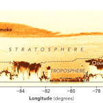
Bushfires have raged in Victoria and New South Wales since November 2019, yielding startling satellite images of smoke plumes streaming from southeastern Australia on a near daily basis. The images got even more eye-popping in January 2020...
Tuesday, February 4th, 2020
Australia’s first space industry incubator has opened applications for its third intake and is looking to help international companies break into the sector. Now in its third year, the Venture Catalyst Space program is based at the University...
Tuesday, February 4th, 2020
Enabling new opportunities in drone-based high-end aerial imaging Copenhagen, Denmark and Altenkirchen, Germany – Phase One Industrial, a world-leading provider of medium format metric cameras and imaging solutions for aerial applications, today announced that it has signed...
Tuesday, February 4th, 2020
Airbus and Hexagon will be joining Geo Connect Asia 2020, South East Asia’s first-ever geospatial services and location intelligence event taking place on 18 and 19 March at Suntec Singapore. What organisers are calling an Asian event...