Tuesday, March 29th, 2011
Intuicom Inc. has announced the availability of support for Trimble's Internet Base Station Service (IBSS) on their RTK Bridge products. IBSS provides GNSS correction information via the Internet using cellular services instead of relying solely on radio...
Tuesday, March 29th, 2011
Around half of the world’s population depends directly or indirectly on mountain resources for different products and services. Having a means for economic valuation of these services will help increase recognition of their value and provide a...
Tuesday, March 29th, 2011
The public can now access the same aerial imagery of Christchurch that Police, Civil Defence, and other emergency responders have been using to assess damage to the area. The imagery of...
Monday, March 28th, 2011
Bing Maps is a worldwide collection of current content and data types, such as street maps, satellite images, Bird’s eye view aerial photos, Streetside panoramic imagery, 3D...
Thursday, March 24th, 2011
The German Remote Sensing Data Center (Deutsches Fernerkundungsdatenzentrum; DFD) and the German Space Operations Center (GSOC), both of which are part of the German Aerospace Center (Deutsches Zentrum für Luft- und Raumfahrt; DLR), are continuing to provide...
Sunday, March 20th, 2011
Trimble announced today that it partnered with Truecount Corporation, an innovator in RFID software solutions for the retail industry. Truecount will leverage ThingMagic enterprise-grade RFID readers to deliver best-in-class item-level RFID platforms for...
Saturday, March 19th, 2011
A dynamic map overlay showing the Road Status after the Earthquake in Sendai, Japan, based on the user generated maps from OpenStreetMap has been generated by Pascal Neis, member of the GIScience Research Group of the University...
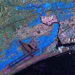
Wednesday, March 16th, 2011
The images were acquired by the German Optical RapidEye and radar TerraSAR-X satellites. They show Torinoumi on the eastern coast of Japan before the disaster on 5 September 2010 and after the tsunami on 12 March 2011....
Tuesday, March 15th, 2011
The Russian-English Agricultural Atlas is the world’s most comprehensive source of information on the geographic distribution of plant-based agriculture in Russia and neighboring countries. The Atlas contains 1500 maps that illustrate the distribution of 100 crops, 560...
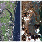
Sunday, March 13th, 2011
RapidEye has acquired two scenes over the West Coast of Honshu Island on Marth 12th. The satellites are already tasked again to image on Sunday, March 13th. The Center for Satellite Based Crisis Information (ZKI) which is part...
