Asian Surveying & Mapping
Breaking News
Esri India Achieves 1 Million Users Milestone
Esri India, the leading provider of Geographic Information System...
Bank Negara, Malaysian Space Agency to bolster financial management ecosystem via space technology
KUALA LUMPUR: Bank Negara Malaysia has partnered with the...
Nepal’s president advisor resigns after criticising inclusion of Indian areas in map on new currency
The economic advisor to Nepal’s president on Sunday (May...
TASA to launch six satellites from 2026
The Taiwan Space Agency (TASA) yesterday said it plans...
Japan to provide flood risk maps for four South-East Asian countries – Indonesia, Vietnam, Thailand and Cambodia
JAKARTA/TOKYO: Japan plans to start providing flood risk maps...
Ecolab and ITE partners to harness water management knowledge for Singapore data center engineers
SINGAPORE, 29 APRIL 2024 – Nalco Water, an Ecolab...
NASA releases satellite photos of Dubai and Abu Dhabi before and after record flooding
NASA released photos of parts of Dubai and Abu...
Singapore releases 10-year Geospatial Master Plan
Singapore has launched its new Geospatial Master Plan (2024–33),...
Japan announces plans to launch upgraded observation satellites on new flagship rocket’s 3rd flight
TOKYO (AP) — Japan’s space agency announced Friday a...
Tesla China partners with Baidu for maps to clear FSD hurdle
Amidst Elon Musk’s unannounced trip to Beijing, China this...

Services

Sunday, May 8th, 2011

Geoscience Australia – Update on Geophysical Data

Geoscience Australia is a prescribed agency within the Resources, Energy and Tourism portfolio, and our Minister is The Hon Martin Ferguson AM MP. Geoscience Australia is a world leader in providing first...

Thursday, May 5th, 2011

EMS Technologies Announces Satellite Communications Study for The Commonwealth of Australia

EMS Technologies, Inc. (NASDAQ: ELMG) a leading provider of aero connectivity and mobile resource management solutions today announced the initiation of a new satellite communications study for The Commonwealth of Australia. The study will assess the feasibility...

Thursday, May 5th, 2011

NAVTEQ Launches its LocationPoint Mobile Ad Network in China

NAVTEQ has launched its location-based mobile ad network, NAVTEQ LocationPoint, in China. This new platform-independent service enables businesses in Singapore and around the world to tap into the fast-developing China market via highly-targeted, relevant and interactive offers...

Tuesday, May 3rd, 2011

Kuwait Institute for Scientific Research Visit SuperGeo for Geospatial Innovation

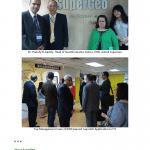
SuperGeo Technologies is honored to be visited by Kuwait Institute for Scientific Research (KISR). The two parties had fruitful discussion about the geospatial applications and innovative collaboration by using GIS technologies. KISR was invited by Institute for Information Industry (III),...

Tuesday, May 3rd, 2011

Nemetschek Vectorworks and MAXON Computer Present ‘Inspired Visions’

Nemetschek Vectorworks, Inc. and MAXON Computer GmbH have teamed up to present the Inspired Visions Global Rendering and Animation Competition. The competition is open to all professional and student designers around the world, and entries will be accepted...

Monday, May 2nd, 2011

Indonesia’s Indigenous Satellite Tracking and Monitoring System

This system is made by Jakarta based PT. Trimega Cipta Kreasindo (TritaK). The system is equl to TDRS system of US. A Tracking and Data Relay Satellite (TDRS) is type of communications satellite, that forms part of...

Wednesday, April 27th, 2011

Clark Labs and UNIGIS Renew Longstanding Partnership

Clark Labs and UNIGIS International are pleased to jointly announce their continued partnership to provide students with access to GIS technology. UNIGIS is the leading worldwide network of universities offering postgraduate Geographic Information Science and Technology education via...

Tuesday, April 26th, 2011

Airman Aims High with Online GIS Degree

When it comes to GIS (Geographic Information Systems) technology, Air Force Tech Sgt. and American Sentinel University student John Spence, understands the growing need for GIS professionals. Based in Tokyo, Japan, Spence is the chief of programs...

Tuesday, April 19th, 2011

National Database of Pakistan’s Cultural Assets Developed

UNESCO has developed a “National Database for Pakistan’s Cultural Assets” to safe guard, conserve and preserve the cultural and natural heritage of NWFP.The database is a Geographical Information System (GIS) compatible database in which contribution was made...

Tuesday, April 19th, 2011

SuperGIS Server 3 Supports Online Editing

SuperGeo Technologies announce that SuperGIS Server 3, its comprehensive enterprise Server GIS software, supports online editing function for efficient editing and updating large map data. SuperGIS Server 3 is a set of comprehensive enterprise GIS software which...

Page 25 of 31 1 20 21 22 23 24 25 26 27 28 29 30 31