
Built on the MFC250 camera platform, the DMC-5 delivers detailed, clear imagery and efficient large-area data acquisition.
Capturing over 30% more data than previous generations, the new system increases coverage and gives operators the flexibility to adapt to a wide range of mapping requirements.
Heerbrugg, Switzerland, (10 November 2026) – Leica Geosystems, part of Hexagon, today announced the Leica DMC-5 next-generation airborne imaging system. Built around the Leica MFC250 camera core within a configurable camera architecture, the DMC-5 helps operators capture large areas more efficiently and gives operators the flexibility to meet different mapping and flight requirements.
More data, tailored to every mission
With two available configurations up to 68,800 pixels across-track, the DMC-5 captures over 30% more data than previous generations, significantly reducing the flight time needed to complete a project. Highly adaptable, field-of-view options range from 36° to 63° in the base configuration and up to 71° in the X configuration, allowing operators to balance image swath and ground resolution to conform to project and airspace requirements.
Building on the Leica DMC product line, deployed by national mapping agencies worldwide, the DMC-5 brings new capabilities to large-format airborne imaging while retaining traditional frame-based outputs for photogrammetric applications.
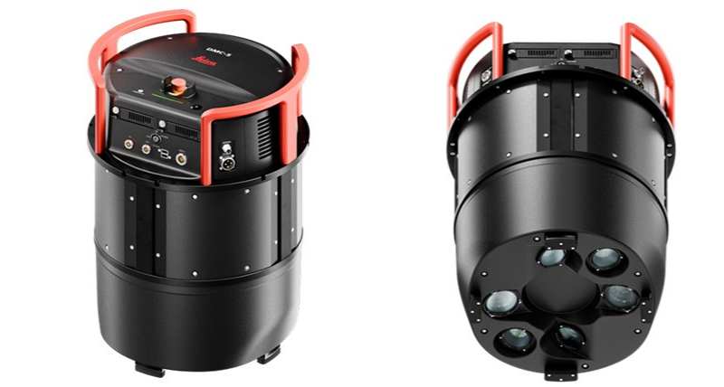
The Leica DMC-5 offers configurations up to 68,800 pixels across-track and field-of-view options from 36° to 63°,enabling greater coverage and flexibility for diverse project requirements.
“Airborne mapping operators are being asked to deliver more, often within increasingly tight operational constraints,” said Tanja Birner, President at Hexagon’s Scanning & Mapping Division. “With the DMC-5, we want to help our customers make the most of every flight, take on new business opportunities and get a better return on their investment. It’s about enabling them to grow their business and stay competitive as market demands evolve.”
Trusted performance from acquisition to deliverables
The DMC-5 leverages Leica Geosystems’ exclusive mechanical forward-motion compensation (FMC) to maintain image sharpness at high aircraft speeds. Complementing this, the Leica PAV gyro-stabilised mount compensates for aircraft motion, supporting consistent image quality throughout every mission.
Integration with Leica HxMap provides a scalable processing workflow from data ingest and radiometric normalisation through to final deliverables.
To learn more about the Leica DMC-5, visit: https://leica-geosystems.com/products/airborne-systems/imaging-sensors/leica-dmc-5
For further information, please contact:
Cristina Mauri, Marketing Lead, Airborne Sensors, Scanning & Mapping Division, Hexagon
Phone: +41 41 727 8948
Email: [email protected]
Hexagon is the global leader in measurement technologies. Our precision measurement, positioning, and autonomous solutions transform the world’s most vital industries. From aerospace & defence, automotive, construction, general manufacturing, to mining and more, we provide the confidence that customers rely on to build, navigate, and innovate.
Hexagon (Nasdaq Stockholm: HEXA B) has approximately 17,500 employees in 50 countries and net sales of approximately 3.7bn EUR.
Learn more at hexagon.com.
