
Fugro has secured a new five‑year indefinite‑delivery, indefinite‑quantity (IDIQ) contract from the U.S. Army Corps of Engineers (USACE) to provide surveying and mapping services supporting civil works and military infrastructure programs across the U.S. and overseas. The contract underpins USACE’s management of critical waterways, flood‑risk systems and military facilities, enabling timely, high‑quality geospatial data to inform infrastructure planning, risk management and operational readiness in complex and demanding environments.
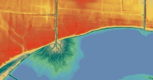
Digital elevation model delivered under Fugro’s previous contract with the U.S. Army Corps of Engineers. Image credit: Fugro.
The award builds on a long‑standing relationship between USACE and Fugro, which has supported Corps programs for more than three decades by delivering accurate, decision‑ready Geo‑data for planning, construction, asset management and environmental stewardship across a wide range of infrastructure systems. The contract is being administered by USACE’s St. Louis District, which plays a leading role in shaping how geospatial data is applied across the Corps’ civil and military activities.
Under the contract, Fugro will deliver work through task orders, collecting high‑resolution geospatial data using crewed and uncrewed platforms and applying cloud‑based, AI‑enabled automation with expert oversight to deliver mapping and survey products. Together, these capabilities support consistent data delivery across diverse operating environments, helping project teams make well‑informed decisions on accelerated timelines.
Task orders from the previous IDIQ illustrate how this work supports USACE priorities in practice. On the civil side, Fugro is delivering mapping and elevation data for the Upper Mississippi River Restoration Program, supporting navigation management and environmental rehabilitation along one of the nation’s busiest inland waterways. For military infrastructure, Fugro is collecting aerial imagery and high‑density lidar data across multiple U.S. Army installation sites in Alaska for land‑use planning, facility maintenance and operational decision‑making in remote and logistically challenging environments.
“The U.S. Army Corps of Engineers relies on consistent, high‑quality geospatial data to plan, maintain and modernize infrastructure across an exceptionally wide range of environments,” said Dave White, Fugro’s Geospatial Program Director in the Americas. “This contract reflects USACE’s need for scalable mapping and survey capability and our ability to deliver reliable, decision‑ready Geo‑data in support of critical infrastructure and national readiness.”
About Fugro
Fugro is the world’s leading Geo-data specialist. With our unique map, model and monitor solutions, we provide project critical insights into the built and natural environment. Fugro supports clients by delivering solutions in support of the energy transition, large-scale infrastructure development and climate resilience. With expertise in site characterization and asset integrity, clients are supported in the safe, sustainable and efficient design, construction and operation of their assets throughout the life cycle. In line with our purpose, we are extending our know-how and solutions to the understanding and preservation of ecosystems.
Employing approximately 10,000 people in 52 countries, Fugro serves clients around the globe, mostly in the energy, infrastructure and water industries, both offshore and onshore. In 2025, revenue amounted to EUR 1.8 billion. Fugro is listed on Euronext Amsterdam.
