
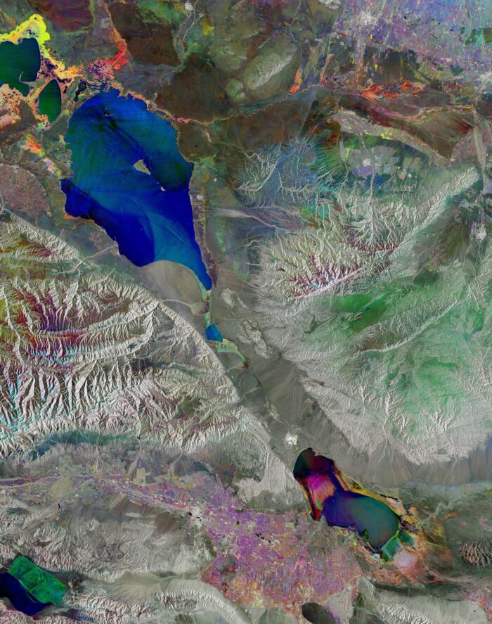
Although radar images are naturally black and white, this false-color composite of Lake Alakol in eastern Kazakhstan results from the combination of three separate radar images acquired a month apart in 2025. Each image has been given a different color: blue for March, green for April and red for May. When the images are overlaid, the resulting colors highlight changes on the ground between acquisitions. Areas that appear gray or white depict little or no change.
Alakol means “multicolored lake” and in this image it can be seen in the top left corner in varying shades of blue and green depending on variations in the frozen surface during the acquisition period. As this saltwater lake usually freezes for about two months at the end of winter, and breaks up in early spring, it appears mainly blue because, during the March acquisition, the surface was mostly frozen.
There are two smaller, shallower lakes to the northwest of Alakol. The closest is Koshkarkol, and part of Sasykkol, a freshwater lake, is also seen in the image. The variety of yellow, pink and magenta colours in the land surrounding the lakes denotes variations in vegetation between March and May.
Lake Alakol is near the border with China’s Xinjiang Uygur Autonomous Region, in an area shaped by the Dzhungarian Gate. This natural valley forms a mountain pass through the Dzungarian Alatau range and connects central Asia to China.
The colorful feature visible south of Alakol is Aibi Lake, or Ebi Lake, the largest saltwater lake in northwest Xinjiang. It has shrunk dramatically over the years and the vibrant colors in the northern part of the basin show where the soil has been exposed during the acquisition period.
Image Credit: Contains modified Copernicus Sentinel data (2025), processed by ESA
